June 28, 2018 06:30 ET | Source: Galway Metals Inc.
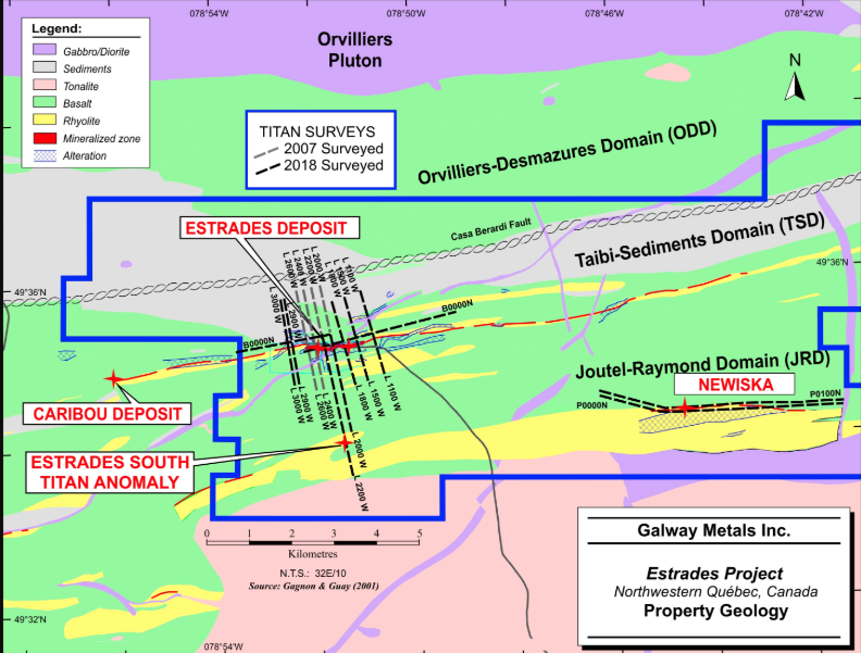
TORONTO, June 28, 2018 (GLOBE NEWSWIRE) — Galway Metals Inc. (TSX-V:GWM) (the “Company” or “Galway”) is pleased to report results from new Titan geophysical surveys recently completed by Galway along the Newiska horizon on the Company’s 20,915 hectare, 100%-owned, Estrades Project in the northern Abitibi of western Quebec, Canada. Highlights include a sizable new geophysical target at the Newiska prospect, 8,000m southeast of the former producing Estrades polymetallic deposit, and a new target, some 2,200m south of the main Estrades deposit, (“Estrades South”). In addition, Galway is pleased to report assay results, highlighting high grade copper intersections from the first drill hole by Galway into the Newiska rhyolite horizon (Figure 1).
Galway Intersects Strong Copper in Wide Area Southeast of Estrades
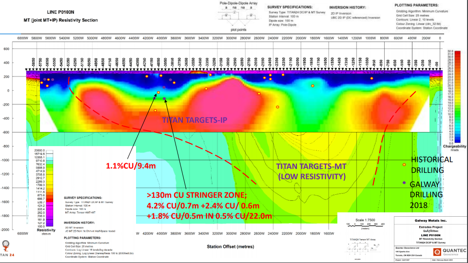
Drill Hole GWM18-NK-01 intersected 4.2% copper over 0.7 metres (see core picture in core box) in a 22.0 metre interval that returned 0.5% copper, hitting the high grade stringer vein some 93 metres from an historic hole that returned 2.0% copper and 37.4 g/t silver over 1.5m in a 9.4 metre interval that returned 1.1% copper and 41.5 g/t Ag. The high-grade stringer vein intervals in both holes contained considerable chalcopyrite. In the new hole, GWM18-NK-01, the high-grade mineralization is part of an extensive 132 metre stringer zone that is present from 328-460 metres. A second stringer zone is present from 141-194 metres. The significance of such stringer zones is that they are commonly found peripheral to major VMS (Volcanogenic Massive Sulfide) deposits, which are a major source of metals such as copper, zinc and lead. Importantly, these drill results are located on the edge of a new geophysical target outlined by Galway’s recently completed Titan geophysical survey, as discussed below, which may indicate the presence of a major, previously unrecognized massive sulfide body at Newiska (Figure 2). Of note is that Galway’s drill program at Newiska occurred prior to the receipt of Titan geophysical results.
New Titan Geophysical Survey Anomaly Below Strong Copper in Drill Hole
At hole GWM18-NK_01, Galway’s new Titan geophysical survey from Quantec Geoscience outlined a strong IP (“Induced Polarization”) conductive zone over 900 metres in length that may correlate with a deep MT (“Magnetotelluric”), less-resistive anomaly extending to depths of 2,000 metres (Figure 2). As this could possibly represent a large body of massive sulfide mineralization, and given the copper-rich stringer zones found peripheral to the location of the anomaly, this represents an exciting new target for follow-up drilling.
New Titan Anomaly South of Estrades Main Deposit
In addition, a second very strong Titan IP chargeability target, “Estrades South,” has been discovered 8,200m west along the same Newiska rhyolite horizon, and located 2,200m south of the Estrades deposit itself. According to Quantec, this target “seems to present the same [geophysical] signature as the Estrades deposit” and “is associated with a conductive zone” below and to depth (Figure 3). Galway believes there has never been any drilling into this area, with the closest known historical drill hole some 400 metres south, and the best drill hole in the area returning 4.7% copper over 0.6 metres in a stringer zone located 1,000m southwest. This new Titan conductive zone also coincides with magnetic and VLF anomalies, making yet another highly prospective drill target that could uncover another volcanogenic massive sulfide (VMS) deposit in the Estrades Camp. This should be seen in the context of the fact that VMS deposits, as seen in many districts around the world, tend to form in clusters and so these two targets could represent other deposits in the same cluster.
“Galway believes that the Estrades and neighbouring Caribou deposits are two parts of a cluster of deposits in the area—which is very common with VMS systems. The upcoming gravity survey likely will corroborate the IP and MT anomalies identified by the Titan survey and may also point to more targets, especially since the gravity survey will encompass a far larger area of the Estrades camp. All those copper-rich stringers at Newiska indicate a big plumbing system that may lead Galway to another sizable deposit.” cites Mike Sutton, V.P. Exploration for Galway Metals.
Updated Resource Expected in Third Quarter
Galway has continued drilling at Estrades in an effort to expand the existing resource (Figure 4). Total drill results reported to date since the acquisition of Estrades in August 2016 is 13,484 metres in 22 holes plus three wedges (in addition to GWM18-NK-01 at Newiska—501 metres). 10 drill holes, and 2 extensions of holes (7,214 metres), have not been released and are awaiting assays at Estrades and 5 holes (2,191 metres) are pending from Newiska. The company has been successful, with drilling located outbound from existing resources returning intersections such as:
72.5 g/t Au over 1.6 metres (true width = 1.0m) in Hole GWM-17E-01,
7.4% Cu over 1.9 m (TW = 1.2m) in Hole GWM-17E-05,
5.1% Cu and 62.0 g/t Ag over 1.65 m (TW = 1.2m), including 12.9% Cu and 159.0 g/t Ag over 0.55 m (TW width = 0.4m), in hole GWM-17E-04, and
22.4 g/t Au, 199.3 g/t Ag, 10.4% Zn and 2.0% Pb over 1.6 m (TW=0.8m), in Hole GWM-17E-16.
The Company has also been successful at drilling newly identified zones, with intersections returned such as:
2.2 g/t Au, 181.0 g/t Ag and 28.5% Zn over 3.3 m (2.1m TW), plus 190.7 g/t Ag and 18.6% Zn over 2.6 m (1.7m TW), plus 5.7 g/t Au and 43.2 g/t Ag over 2.6 m (unknown TW), plus 4.7 g/t Au, 67.5 g/t Ag, 4.9% Zn, 2.1% Cu and 1.0% Pb over 1.8m (1.1m TW) in GWM-17E-27,
5.2 g/t Au, 198.7 g/t Ag, 15.7% Zn and 1.3% Pb over 1.5 m (0.8 m TW), plus 2.3 g/t Au, 65.7 g/t Ag and 12.6% Zn over 2.1 m (1.2 m TW) in GWM-17E-24,
6.9 g/t Au, 78.5 g/t Ag and 1.7% Zn over 6.4 m (4.4m TW) in GWM-18E-31, and
1.1 g/t Au, 95.2 g/t Ag and 4.2% Zn over 17.7 m (including 1.7 g/t Au, 190.9 g/t Ag, 9.7% Zn and 1.3% Cu over 4.5 m, and 1.0 g/t Au, 147.6 g/t Ag and 8.3% Zn over 2.0 m) (unknown TW) in GWM-17E-08.
The priority was to drill off gaps in the 1.8 km long resource to create more resources along this sheet of vertical mineralization.
On August 18, 2016, Galway published a NI 43-101 compliant Estrades resource estimate (Table 1), which included Indicated Resources of 518,000 ounces at 12.4 g/t gold equivalent (or 652,000,000 lbs at 22.8% zinc equivalent), plus Inferred Resources of 290,000 ounces at 7.4 g/t gold equivalent (or 366,000,000 lbs at 13.6% zinc equivalent) (refer to Galway’s website at www.galwaymetalsinc.com for details on the Estrades resource estimate). The Estrades project was previously mined via a 200 metre deep ramp, with production in 1990-91 totaling 174,946 tonnes grading 12.9% Zn, 6.4 g/t Au, 1.1% Cu and 172.3 g/t Ag.
Galway is planning to release an updated resource in the next few months, taking into account new drilling results conducted since the 2016 resource.
Table 2: Drill Result Highlights
Hole ID From
(m) To
(m) Intercept
(m) TW
(m) Au
(g/t) Ag
(g/t) Zn
(%) Cu
(%) Pb
(%) Type**
GWM18-NK-01 149.4 150.1 0.7 0.5 DSS
347.6 348.1 0.5 0.8 DSS
348.1 348.9 0.8 0.5 DSS
364.9 366.0 1.1 0.8 DSS
370.6 371.2 0.6 22.3 1.6 0.7 DSS
390.4 392.2 1.8 12.9 0.5 DSS
403.9 404.4 0.5 0.5 DSS
405.6 406.3 0.8 0.3 33.7 0.2 0.7 DSS
423.0 445.0 22.0 12.8 0.5 DSS
including 423.9 424.6 0.7 122.1 4.2 DSS
including 432.8 433.4 0.6 53.5 2.4 DSS
including 437.4 437.7 0.5 39.5 1.8 DSS
including 439.3 440.0 0.7 0.9 20.7 0.9 DSS
472.0 472.7 0.7 0.6 0.3 DSS
Notes:
** MSS = massive sulphide, SMS = semi-massive sulphide DSS = disseminated and stringer sulphides.
If true width (TW) is not specified, the orientation of the zone is unknown at this time.
Estrades, Newiska, and Casa Berardi Geology and Mineralization
Information on Geology and Mineralization can be found on the Estrades project page of our website at www.galwaymetalsinc.com along with a complete Table of Drill Results released to date.
Review by Qualified Person, Quality Control and Reports
In compliance with National Instrument 43-101, Mr. Mike Sutton, P.Geo., is the Qualified Person responsible for the accuracy of this news release. Mr. Reno Pressacco, P. Geo., is the Qualified Person responsible for preparation and disclosure of the Estrades Mineral Resource estimate, and is independent of Galway. The drill core is sawn in half with one half of the core sample shipped to Swastika Laboratories situated in Swastika, ON, which has accreditation of ISO/IEC 17025. The other half of the core is retained for future assay verification. Other QA/QC measures includes the insertion of certified reference standards (gold and polymetallics) and blanks into the sample stream, and the regular re-assaying of pulps and rejects at alternate certified labs. Gold analysis is conducted by fire assay using atomic absorption or gravimetric finish for samples greater than 10 g/Mt gold. Other Metals (Ag, Cu, Pb, Zn, Co, As) have full acid digestion and analyzed by AAS; with over limits (5000 PPM) analyzed by AAS using method dilutions, and the Silver (Ag) over limits (> 200 ppm) analyzed by fire assay (FA) & gravimetric finish. The laboratory re-assays at least 10% of all samples and additional checks may be run on anomalous values.
Table 3: Drill Hole Coordinates
Hole ID Azimuth Dip Northing Easting Hole Length (m)
GWM18-NK-01 9.3 -70 5493148 662993 501
About the Company
Galway Metals is well capitalized with two projects in Canada: Clarence Stream, an emerging gold district in New Brunswick, and Estrades, the former producing, high-grade VMS mine in Quebec. The Company began trading on January 4, 2013, after its successful spinout to existing shareholders from Galway Resources following the completion of the US$340 million sale of that company. With substantially the same management team and Board of Directors, Galway Metals is keenly intent on creating similar value as it had with Galway Resources.
Should you have any questions and for further information, please contact (toll free):
Galway Metals Inc.
Robert Hinchcliffe
President & Chief Executive Officer
1-800-771-0680
www.galwaymetalsinc.com
CAUTIONARY STATEMENT: Neither the TSX Venture Exchange nor its Regulation Services Provider (as that term is defined in the policies of the TSX Venture Exchange) accepts responsibility for the adequacy of this news release. No stock exchange, securities commission or other regulatory authority has approved or disapproved the information contained herein.
This news release contains forward-looking information, which is not comprised of historical facts. Forward-looking information involves risks, uncertainties and other factors that could cause actual events, results, performance, prospects and opportunities to differ materially from those expressed or implied by such forward-looking information. Forward-looking information in this news release includes statements made herein with respect to, among other things, the Company’s objectives, goals or future plans, potential corporate and/or property acquisitions, exploration results, potential mineralization, exploration and mine development plans, timing of the commencement of operations, and estimates of market conditions. Factors that could cause actual results to differ materially from such forward-looking information include, but are not limited to, exploration results being less favourable than anticipated, capital and operating costs varying significantly from estimates, delays in obtaining or failures to obtain required governmental, environmental or other project approvals, political risks, uncertainties relating to the availability and costs of financing needed in the future, changes in equity markets, inflation, changes in exchange rates, fluctuations in commodity prices, delays in the development of projects, risks associated with the defence of legal proceedings and other risks involved in the mineral exploration and development industry, as well as those risks set out in the Company’s public disclosure documents filed on SEDAR. Although the Company believes that management’s assumptions used to develop the forward-looking information in this news release are reasonable, including that, among other things, the Company will be able to identify and execute on opportunities to acquire mineral properties, exploration results will be consistent with management’s expectations, financing will be available to the Company on favourable terms when required, commodity prices and foreign exchange rates will remain relatively stable, and the Company will be successful in the outcome of legal proceedings, undue reliance should not be placed on such information, which only applies as of the date of this news release, and no assurance can be given that such events will occur in the disclosed time frames or at all. The Company disclaims any intention or obligation to update or revise any forward-looking information contained herein, whether as a result of new information, future events or otherwise, except as required by applicable securities laws.
Galway Metals Outlines Significant New Titan Geophysical Targets and Drills 4.2% Copper Over 0.7m at Newiska at its Estrades Project, Quebec
June 28, 2018 06:30 ET | Source: Galway Metals Inc.
TORONTO, June 28, 2018 (GLOBE NEWSWIRE) — Galway Metals Inc. (TSX-V:GWM) (the “Company” or “Galway”) is pleased to report results from new Titan geophysical surveys recently completed by Galway along the Newiska horizon on the Company’s 20,915 hectare, 100%-owned, Estrades Project in the northern Abitibi of western Quebec, Canada. Highlights include a sizable new geophysical target at the Newiska prospect, 8,000m southeast of the former producing Estrades polymetallic deposit, and a new target, some 2,200m south of the main Estrades deposit, (“Estrades South”). In addition, Galway is pleased to report assay results, highlighting high grade copper intersections from the first drill hole by Galway into the Newiska rhyolite horizon (Figure 1).
Galway Intersects Strong Copper in Wide Area Southeast of Estrades
Drill Hole GWM18-NK-01 intersected 4.2% copper over 0.7 metres (see core picture in core box) in a 22.0 metre interval that returned 0.5% copper, hitting the high grade stringer vein some 93 metres from an historic hole that returned 2.0% copper and 37.4 g/t silver over 1.5m in a 9.4 metre interval that returned 1.1% copper and 41.5 g/t Ag. The high-grade stringer vein intervals in both holes contained considerable chalcopyrite. In the new hole, GWM18-NK-01, the high-grade mineralization is part of an extensive 132 metre stringer zone that is present from 328-460 metres. A second stringer zone is present from 141-194 metres. The significance of such stringer zones is that they are commonly found peripheral to major VMS (Volcanogenic Massive Sulfide) deposits, which are a major source of metals such as copper, zinc and lead. Importantly, these drill results are located on the edge of a new geophysical target outlined by Galway’s recently completed Titan geophysical survey, as discussed below, which may indicate the presence of a major, previously unrecognized massive sulfide body at Newiska (Figure 2). Of note is that Galway’s drill program at Newiska occurred prior to the receipt of Titan geophysical results.
New Titan Geophysical Survey Anomaly Below Strong Copper in Drill Hole
At hole GWM18-NK_01, Galway’s new Titan geophysical survey from Quantec Geoscience outlined a strong IP (“Induced Polarization”) conductive zone over 900 metres in length that may correlate with a deep MT (“Magnetotelluric”), less-resistive anomaly extending to depths of 2,000 metres (Figure 2). As this could possibly represent a large body of massive sulfide mineralization, and given the copper-rich stringer zones found peripheral to the location of the anomaly, this represents an exciting new target for follow-up drilling.
New Titan Anomaly South of Estrades Main Deposit
In addition, a second very strong Titan IP chargeability target, “Estrades South,” has been discovered 8,200m west along the same Newiska rhyolite horizon, and located 2,200m south of the Estrades deposit itself. According to Quantec, this target “seems to present the same [geophysical] signature as the Estrades deposit” and “is associated with a conductive zone” below and to depth (Figure 3). Galway believes there has never been any drilling into this area, with the closest known historical drill hole some 400 metres south, and the best drill hole in the area returning 4.7% copper over 0.6 metres in a stringer zone located 1,000m southwest. This new Titan conductive zone also coincides with magnetic and VLF anomalies, making yet another highly prospective drill target that could uncover another volcanogenic massive sulfide (VMS) deposit in the Estrades Camp. This should be seen in the context of the fact that VMS deposits, as seen in many districts around the world, tend to form in clusters and so these two targets could represent other deposits in the same cluster.
“Galway believes that the Estrades and neighbouring Caribou deposits are two parts of a cluster of deposits in the area—which is very common with VMS systems. The upcoming gravity survey likely will corroborate the IP and MT anomalies identified by the Titan survey and may also point to more targets, especially since the gravity survey will encompass a far larger area of the Estrades camp. All those copper-rich stringers at Newiska indicate a big plumbing system that may lead Galway to another sizable deposit.” cites Mike Sutton, V.P. Exploration for Galway Metals.
Updated Resource Expected in Third Quarter
Galway has continued drilling at Estrades in an effort to expand the existing resource (Figure 4). Total drill results reported to date since the acquisition of Estrades in August 2016 is 13,484 metres in 22 holes plus three wedges (in addition to GWM18-NK-01 at Newiska—501 metres). 10 drill holes, and 2 extensions of holes (7,214 metres), have not been released and are awaiting assays at Estrades and 5 holes (2,191 metres) are pending from Newiska. The company has been successful, with drilling located outbound from existing resources returning intersections such as:
72.5 g/t Au over 1.6 metres (true width = 1.0m) in Hole GWM-17E-01,
7.4% Cu over 1.9 m (TW = 1.2m) in Hole GWM-17E-05,
5.1% Cu and 62.0 g/t Ag over 1.65 m (TW = 1.2m), including 12.9% Cu and 159.0 g/t Ag over 0.55 m (TW width = 0.4m), in hole GWM-17E-04, and
22.4 g/t Au, 199.3 g/t Ag, 10.4% Zn and 2.0% Pb over 1.6 m (TW=0.8m), in Hole GWM-17E-16.
The Company has also been successful at drilling newly identified zones, with intersections returned such as:
2.2 g/t Au, 181.0 g/t Ag and 28.5% Zn over 3.3 m (2.1m TW), plus 190.7 g/t Ag and 18.6% Zn over 2.6 m (1.7m TW), plus 5.7 g/t Au and 43.2 g/t Ag over 2.6 m (unknown TW), plus 4.7 g/t Au, 67.5 g/t Ag, 4.9% Zn, 2.1% Cu and 1.0% Pb over 1.8m (1.1m TW) in GWM-17E-27,
5.2 g/t Au, 198.7 g/t Ag, 15.7% Zn and 1.3% Pb over 1.5 m (0.8 m TW), plus 2.3 g/t Au, 65.7 g/t Ag and 12.6% Zn over 2.1 m (1.2 m TW) in GWM-17E-24,
6.9 g/t Au, 78.5 g/t Ag and 1.7% Zn over 6.4 m (4.4m TW) in GWM-18E-31, and
1.1 g/t Au, 95.2 g/t Ag and 4.2% Zn over 17.7 m (including 1.7 g/t Au, 190.9 g/t Ag, 9.7% Zn and 1.3% Cu over 4.5 m, and 1.0 g/t Au, 147.6 g/t Ag and 8.3% Zn over 2.0 m) (unknown TW) in GWM-17E-08.
The priority was to drill off gaps in the 1.8 km long resource to create more resources along this sheet of vertical mineralization.
On August 18, 2016, Galway published a NI 43-101 compliant Estrades resource estimate (Table 1), which included Indicated Resources of 518,000 ounces at 12.4 g/t gold equivalent (or 652,000,000 lbs at 22.8% zinc equivalent), plus Inferred Resources of 290,000 ounces at 7.4 g/t gold equivalent (or 366,000,000 lbs at 13.6% zinc equivalent) (refer to Galway’s website at www.galwaymetalsinc.com for details on the Estrades resource estimate). The Estrades project was previously mined via a 200 metre deep ramp, with production in 1990-91 totaling 174,946 tonnes grading 12.9% Zn, 6.4 g/t Au, 1.1% Cu and 172.3 g/t Ag.
Galway is planning to release an updated resource in the next few months, taking into account new drilling results conducted since the 2016 resource.
Table 2: Drill Result Highlights
Hole ID From
(m) To
(m) Intercept
(m) TW
(m) Au
(g/t) Ag
(g/t) Zn
(%) Cu
(%) Pb
(%) Type**
GWM18-NK-01 149.4 150.1 0.7 0.5 DSS
347.6 348.1 0.5 0.8 DSS
348.1 348.9 0.8 0.5 DSS
364.9 366.0 1.1 0.8 DSS
370.6 371.2 0.6 22.3 1.6 0.7 DSS
390.4 392.2 1.8 12.9 0.5 DSS
403.9 404.4 0.5 0.5 DSS
405.6 406.3 0.8 0.3 33.7 0.2 0.7 DSS
423.0 445.0 22.0 12.8 0.5 DSS
including 423.9 424.6 0.7 122.1 4.2 DSS
including 432.8 433.4 0.6 53.5 2.4 DSS
including 437.4 437.7 0.5 39.5 1.8 DSS
including 439.3 440.0 0.7 0.9 20.7 0.9 DSS
472.0 472.7 0.7 0.6 0.3 DSS
Notes:
** MSS = massive sulphide, SMS = semi-massive sulphide DSS = disseminated and stringer sulphides.
If true width (TW) is not specified, the orientation of the zone is unknown at this time.
Estrades, Newiska, and Casa Berardi Geology and Mineralization
Information on Geology and Mineralization can be found on the Estrades project page of our website at www.galwaymetalsinc.com along with a complete Table of Drill Results released to date.
Review by Qualified Person, Quality Control and Reports
In compliance with National Instrument 43-101, Mr. Mike Sutton, P.Geo., is the Qualified Person responsible for the accuracy of this news release. Mr. Reno Pressacco, P. Geo., is the Qualified Person responsible for preparation and disclosure of the Estrades Mineral Resource estimate, and is independent of Galway. The drill core is sawn in half with one half of the core sample shipped to Swastika Laboratories situated in Swastika, ON, which has accreditation of ISO/IEC 17025. The other half of the core is retained for future assay verification. Other QA/QC measures includes the insertion of certified reference standards (gold and polymetallics) and blanks into the sample stream, and the regular re-assaying of pulps and rejects at alternate certified labs. Gold analysis is conducted by fire assay using atomic absorption or gravimetric finish for samples greater than 10 g/Mt gold. Other Metals (Ag, Cu, Pb, Zn, Co, As) have full acid digestion and analyzed by AAS; with over limits (5000 PPM) analyzed by AAS using method dilutions, and the Silver (Ag) over limits (> 200 ppm) analyzed by fire assay (FA) & gravimetric finish. The laboratory re-assays at least 10% of all samples and additional checks may be run on anomalous values.
Table 3: Drill Hole Coordinates
Hole ID Azimuth Dip Northing Easting Hole Length (m)
GWM18-NK-01 9.3 -70 5493148 662993 501
About the Company
Galway Metals is well capitalized with two projects in Canada: Clarence Stream, an emerging gold district in New Brunswick, and Estrades, the former producing, high-grade VMS mine in Quebec. The Company began trading on January 4, 2013, after its successful spinout to existing shareholders from Galway Resources following the completion of the US$340 million sale of that company. With substantially the same management team and Board of Directors, Galway Metals is keenly intent on creating similar value as it had with Galway Resources.
Should you have any questions and for further information, please contact (toll free):
Galway Metals Inc.
Robert Hinchcliffe
President & Chief Executive Officer
1-800-771-0680
www.galwaymetalsinc.com
CAUTIONARY STATEMENT: Neither the TSX Venture Exchange nor its Regulation Services Provider (as that term is defined in the policies of the TSX Venture Exchange) accepts responsibility for the adequacy of this news release. No stock exchange, securities commission or other regulatory authority has approved or disapproved the information contained herein.
This news release contains forward-looking information, which is not comprised of historical facts. Forward-looking information involves risks, uncertainties and other factors that could cause actual events, results, performance, prospects and opportunities to differ materially from those expressed or implied by such forward-looking information. Forward-looking information in this news release includes statements made herein with respect to, among other things, the Company’s objectives, goals or future plans, potential corporate and/or property acquisitions, exploration results, potential mineralization, exploration and mine development plans, timing of the commencement of operations, and estimates of market conditions. Factors that could cause actual results to differ materially from such forward-looking information include, but are not limited to, exploration results being less favourable than anticipated, capital and operating costs varying significantly from estimates, delays in obtaining or failures to obtain required governmental, environmental or other project approvals, political risks, uncertainties relating to the availability and costs of financing needed in the future, changes in equity markets, inflation, changes in exchange rates, fluctuations in commodity prices, delays in the development of projects, risks associated with the defence of legal proceedings and other risks involved in the mineral exploration and development industry, as well as those risks set out in the Company’s public disclosure documents filed on SEDAR. Although the Company believes that management’s assumptions used to develop the forward-looking information in this news release are reasonable, including that, among other things, the Company will be able to identify and execute on opportunities to acquire mineral properties, exploration results will be consistent with management’s expectations, financing will be available to the Company on favourable terms when required, commodity prices and foreign exchange rates will remain relatively stable, and the Company will be successful in the outcome of legal proceedings, undue reliance should not be placed on such information, which only applies as of the date of this news release, and no assurance can be given that such events will occur in the disclosed time frames or at all. The Company disclaims any intention or obligation to update or revise any forward-looking information contained herein, whether as a result of new information, future events or otherwise, except as required by applicable securities laws.
Geological and Geophysical Data Define Vectors to a Potential Sullivan-Type Massive Sulphide Target on PJX Resources’ DD Property
Toronto, Ontario – April 24, 2018 – PJX Resources Inc.’s (“PJX”) is pleased to announce that geological and geophysical data define vectors to a potential Sullivan Type massive sulphide (zinc-lead-silver) target on its DD Property, located approximately 35 kilometres southwest of Cranbrook, BC. See PJX’s website for additional information.
“Historical drilling adjacent to the DD Property define geological and geochemical vectors for a potential Sullivan-type system, which increase toward the DD Property,” states Dave Pighin, PGeo for PJX Resources. “The Sullivan deposit occurs at a geological time called the Sullivan Horizon. The thickness, alteration and anomalous zinc-lead concentrations of the Sullivan Horizon progressively increases in intensity the closer holes are drilled to the DD Property. A similar increase in thickness, alteration and anomalous zinc-lead concentrations in the Sullivan Horizon occurs in proximity to the Sullivan Deposit.”
“The Magnetotelluric (MT) geophysical survey carried out by Quantec Geoscience on the DD Property has defined a MT anomaly that appears to coincide with the anticipated depth of the favourable Sullivan Horizon,” states the President and CEO of PJX, John Keating. “The Sullivan deposit contained iron sulphides that could be detected by an MT survey and cause an MT anomaly. The MT anomaly on the DD Property occurs on two widely spaced lines, 700 metres apart, and is open to the north and south. The DD Property MT anomaly is at a depth and a size that supports the potential for a Sullivan Type target.”
DOWNLOAD Presentation
PJX Resources Inc – dd-maps-and-sections
Quantec at Geophysics session at CIM
He then spent 27 years with the Utah/BHP Minerals company during which time as Chief Geophysicist, he championed BHP’s programs in airborne geophysics which resulted in the development of the MegaTEM and Falcon technologies. In 1999, Ken helped form a technology-focused service company that specializes in the application of innovative processing and data analysis to help drive the discovery of new mineral deposits.
General Moly spots Cu-Ag target at Mt. Hope
LAKEWOOD, COLO. — General Moly Inc. reported March 1 that has identified a potential high-grade, copper-silver exploration target along with a significant zinc mineralized area at the Mt. Hope Project site, southeast of the Mt. Hope’s molybdenum deposit in central Nevada.
A review of historic drill results and a geophysical survey of Mt. Hope form the basis to commence a robust geologic review and further evaluation via a new 2018 exploration program, focused primarily on a high-grade copper-silver target, subject to further financing.
The Mt. Hope molybdenum project is 21 miles north of Eureka and has approximately 65 percent of engineering completed with no current engineering work in progress, while it is undergoing final phases of permitting to reobtain its water permits and record of decision. The company also wholly owns the Liberty Project, a molybdenum and copper property in central Nevada. Molybdenum is a metallic element used primarily as an alloy agent in steel manufacturing and in the chemical and petrochemical industries.
Because of the copper-silver target and zinc mineralization, General Moly undertook a high-intensity, ground-based induced polarization survey to determine if potential continuity and the size of the mineralization would justify additional exploration and evaluation. The IP survey was completed in February 2018 by Quantec Geoscience and indicates a fairly continuous group of high chargeability anomalies that appear aligned with the recently identified copper-silver target.
Magnetotelluric (MT) Survey Completed on PJX Resources’ DD Property
Toronto, Ontario – March 05, 2018 – PJX Resources Inc. (“PJX”) is pleased to announce that Teck Resources Limited (“Teck”) has completed a Magnetotelluric (MT) geophysical survey which identified a conductive anomaly in a geological environment favourable to host a Sullivan Type deposit on the DD Property located in the Cranbrook area of British Columbia.
The MT survey carried out by Quantec Geoscience for Teck has defined a MT anomaly that appears to coincide with the anticipated depth of the Sullivan horizon. The anomaly occurs on the DD Property within a sedimentary basin called the Panda Basin that is geologically similar to the Sullivan Basin hosting the Sullivan deposit located about 45 km to the north. Teck is assessing the MT target for drilling and is in the process of applying for the relevant permits.
“Historical drilling by other companies in the Panda Basin indicates that the Sullivan time sedimentary horizon that hosts the Sullivan deposit increases significantly in thickness and anomalous zinc-lead mineralization the closer drilling gets to the DD Property”, states Dave Pighin, PGeo for PJX Resources. “This increasing thickness is similar to what occurs at the Sullivan Deposit in the Sullivan Basin. The Sullivan horizon is approximately 2 m thick at about 8 km from the Sullivan deposit and increases to over 60 m thick at the deposit. The thickness of the Sullivan time horizon in the Panda Basin is much greater than the Sullivan Basin. A series of 4 widely spaced historical holes drilled in the Panda Basin show that the Sullivan time horizon is 43m thick with 3.5m of anomalous zinc and lead mineralization at about 5.5km from the DD Property (Drill Hole L80-1). The Sullivan horizon and anomalous mineralization increase in thickness the closer drilling gets to the DD Property. The closest hole (IR07-1) drilled adjacent to the DD Property intersected over 194m of Sullivan horizon with 36m of geochemically anomalous zinc and lead.”
LEXI Announces Positive Geophysical Results Interpreted as a Thick, Continuous Brine Discovery at Antofalla Salar
TORONTO, March 27, 2018 (GLOBE NEWSWIRE) — Lithium Energi Exploration, Inc. (TSXV:LEXI) (“LEXI” or the “Company”) is pleased to announce positive results from its initial geophysical surveys on each of the first three concessions studied in the northern section of its holdings in the Antofalla Salar. Interpreted brine horizons were detected throughout the entire 80 km2 area of these concessions, inferring the possibility that lithium-bearing brine exists beneath the properties in the northern area of the Antofalla Salar. The survey results received to date indicate that conductive horizons have been detected from just below surface to as much as 400 meters in depth.
LEXI’s Director of Exploration, Miles Rideout, noted, “Having conducted or supervised the acquisition of thousands of kilometers of TEM soundings in brine environments over the last thirty years, I’m pleased to report that the initial geophysical results exceeded our expectations. The highly conductive units encountered correlate with known brine aquifers and these data allow us to follow these target zones under areas of thick cover.”
Quantec to present at the TGDG Innovation Forum
Rob Gordon, P.Eng., Geophysicist will present at the upcoming Toronto Geological Discussion Group – Innovation Symposium on April 3rd, 2018
APRIL 3, 2018
Topic: Innovations in exploration imaging technology, implications for improved drill targetting
Quantec to present at the Northwest Prospectors Showcase
Rob Gordon of Quantec will be presenting on Thursday April 5th at the Northwestern Ontario Prospectors association meeting.
Time of presentation is 9 AM.
Topic : Innovations in exploration search technology and earth imaging.
Quantec reports successful PDAC
BELMONT RECEIVES RESULTS OF MAGNETOTELLURIC (MT) SURVEY ON THE KIBBY BASIN – NEVADA LITHIUM PROPERTY
Vancouver, B.C. Canada, March 1, 2018 – Belmont Resources Inc. (TSX.V: BEA; FSE: L3L1; DTC Eligible – CUSIP 080499403); (“Belmont”, or the “Company”)
Further to our news release of January 23, 2018 in which Belmont announced the commencing by Quantec Geoscience Limited (“Quantec”) of the Spartan AMT/MT Survey.
Belmont is pleased to announce the receipt of the Geophysical Report for Spartan Magnetotelluric (MT) Survey over the KibbyBasin property, carried out by Quantec. The survey covered most of Belmont’s Kibby Basin-Nevada claims and included the playa basin area as well as some of the adjoining higher level lands.
The MT survey and 3D inversion report clearly mapped a more conductive zone at many of thesurvey stations. This variation of the resistivity at depth is interpreted by Quantec as being a potential contact with sub-surface brine that may contain lithium.
The results of the MT survey are a critical source of information and provides a vital step that allows Belmont to select the most prospective locations and higherprobability brine aquifer targets for the next phase of drilling in 2018. Locations where the potential brine contacts are closest to the playa surface are being considered by Belmont as themost favourable targets.
The survey was completed in January, 2018 by field staff from Quantec and measured MT data at a total of 49 sites distributed along an XY grid with a site separation of 1000 metres, comprising approximately 36 square kilometers. The MT data were analyzed using 3D inversion which provides Belmont with a 3D model of the property from the surface down to 3 kilometers depth.
The results of the Quantec MT survey correlated well with information previously obtained from the gravity survey modeling (Wright Geophysics -2016). Quantec’s MT survey results clearly map a more conductive zone beginning at approximately 500m depth.