Cascadia Samples 9.01% Copper and Prepares for 2024 Diamond Drilling at PIL Property, British Columbia
January 9, 2024 – Vancouver, BC – Cascadia Minerals Ltd. (“Cascadia”) (TSX-V:CAM) is pleased to provide results of the 2023 exploration program at the PIL Property, located in the prolific Toodoggone porphyry copper-gold and epithermal precious metals district of northern British Columbia, Canada. Work in 2023 included a TITAN deep induced polarization (“IP”) geophysical survey at the PIL South target, as well as prospecting and mapping focused primarily in the underexplored northeastern portion of the property, at the Spruce target.
PIL 2023 Exploration Summary
- Deep IP survey at the PIL South target identified a classic porphyry signature below shallow historical drilling that intersected typical high-level pyrite mineralization and alteration;
- The IP survey signature underlies a 2.5 x 2.0 km gold-copper ± molybdenum soil and rock sample anomaly at surface;
- Prospecting at the Spruce target identified significant copper, silver and molybdenum samples along a 2.6 km trend;
- Spruce rock sample highlights include 9.01% copper with 212 g/t silver and 0.26 g/t gold in float, and 3.75% copper with 101 ppm molybdenum in outcrop; and
- Planning is underway for 2024 exploration, including diamond drilling at PIL South in 2024 to test the porphyry target at depth and geophysics and mapping to prepare Spruce for drilling.
“We are very encouraged by the deep IP survey at the PIL South target as it returned compelling indications of porphyry copper mineralization at depth, beneath historical shallow drilling. We plan to undertake our first diamond drill program at PIL this summer, focusing on testing PIL South at depth,” said Graham Downs, Cascadia’s President and CEO. “The prospecting results from the recently identified Spruce target are also very exciting. We have now defined a 2.6 km mineralized trend in this area with alteration profiles suggestive of porphyry mineralization. We will continue to systematically advance Spruce in 2024, with geophysics, surface work, and drilling if warranted.”

Figure 1 – PIL Property Copper-in-Soil Map

Figure 2 – PIL South Copper-in-Soil Map

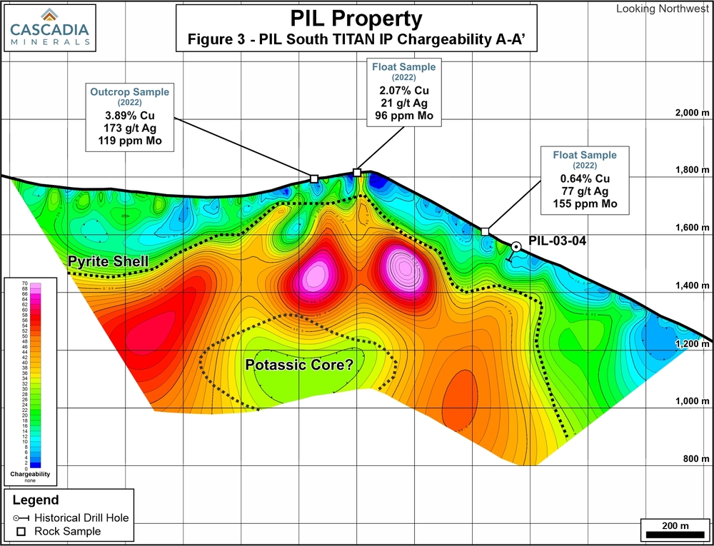
Figure 3 – PIL South TITAN IP Chargeability Section A-A’

Figure 4 – PIL South TITAN IP Resistivity Section A-A’

PIL South TITAN IP Survey Results
A TITAN deep IP geophysical survey was conducted at the PIL South target in 2023, in an area with strong surface mineralization, limited historical drilling, and a strong response from a shallower conventional IP survey completed in 2022. Two perpendicular TITAN IP lines were completed, totaling 4.8 line-km (Figure 2).
Results of this survey are suggestive of the potential for a buried porphyry target underneath the shallow historical drilling. The chargeability response exhibits a broad zone of very high-chargeability around a deeper zone of moderate chargeability, suggestive of a pyrite halo around the core of a porphyry system (Figure 3) at the 1,200 m elevation level. The resistivity response shows a core zone of moderate resistivity with moderate chargeability values that could represent the potassic core (Figure 4).
Three shallow historical drillholes were completed by a previous operator at this target in 2003, with no significant intercepts of copper mineralization. Core from these holes were reviewed in detail this season and exhibits high-level alteration signatures (propylitic to sericite alteration), as well as zones of significant pyrite, and short intervals of anomalous copper and gold. This supports the interpretation of the IP signature, suggesting the presence of a pyrite shell – intersected by historical drilling – potentially adjacent to the potassic core of a porphyry that has never been drill tested.
Cascadia plans to drill-test this hypothesized potassic core in 2024, embarking on its first diamond drilling campaign at the PIL property.
Prospecting and Mapping Results
Fieldwork in 2023 included the collection of 420 soil samples and 186 rock samples. Exploration was focused on the Spruce and PIL South areas, with expansion of soil grids at both targets (Figure 1). Contour sampling and prospecting was also completed in various underexplored areas between the two targets.
Rock sampling at Spruce identified mineralization in float and outcrop across a 2.6 km trend northwest of the original 2022 discovery outcrop, in an area that has seen no historical exploration. Grab samples returned results including 3.75% copper with 101 ppm molybdenum in outcrop, 2.07% copper in outcrop, and 9.01% copper with 212 g/t silver and 0.26 g/t gold in talus (Figure 5). The alteration assemblage and trace element signature of samples in this area are strongly suggestive of porphyry style mineralization at depth. Given the extensive nature of mineralization at Spruce, planning is underway for follow-up work in 2024.
Soil sampling results extended the known PIL South anomaly further to the east, and identified a new area of potential mineralization 3 km south of the Spruce target (Figure 1). These areas will be further evaluated in 2024.
Property Geology and Mineralization
The 151 km2 PIL Property is located in the heart of the 90 x 20 km northwest-trending Toodoggone district in northern British Columbia, within the eastern part of the Stikine Terrane. The Stikine Terrane is juxtaposed against the Quesnel Terrane by the 1,000+ km long, deep seated, crustal scale strike-slip Teslin-Thibert fault approximately 8 km northeast of the property boundary. Stikine and Quesnel Terranes are characterized by similar Late Triassic to Early Jurassic volcanic-plutonic arc complexes that host numerous porphyry copper-gold-molybdenum mines, deposits and prospects including Red Chris (Newmont Mining), Galore Creek (Teck/Newmont), Kemess (Centerra Gold), and Mount Milligan (Centerra Gold). Numerous epithermal gold-silver projects are also found in the region, including Brucejack (Newmont Mining), Ranch (Thesis Gold) and Lawyers (Thesis Gold).
The Toodoggone district is underlain by volcanic and sedimentary rocks of the Early to Middle Jurassic Hazelton Group and the coeval Early Jurassic Black Lake Plutonic intrusive complex. There is a prominent northwest-trending regional structural fabric with the strata in the Toodoggone disrupted by several steeply dipping normal faults, strike-slip faults and thrust faults.
The Property is under option from Finlay Minerals Ltd., and Cascadia has the ability to acquire a 70% interest in the project by making a series of staged payments and work expenditures. For more details on the Property, please visit our website at www.cascadiaminerals.com.
About Cascadia
Cascadia is a Canadian junior mining company focused on exploring for copper and gold in the Yukon and British Columbia. Cascadia’s flagship Catch Property in the Yukon hosts a brand-new copper-gold porphyry discovery where inaugural drill results returned broad intervals of mineralization, including 116.60 m of 0.31% copper with 0.30 g/t gold. Catch exhibits extensive high-grade copper and gold mineralization across a 5 km long trend, with rock samples returning peak values of 3.88% copper and 30.00 g/t gold.
In addition to Catch, Cascadia is conducting exploration work at its PIL Property in British Columbia and the Sands of Time and Rosy properties in the Yukon, as well as evaluating additional regional opportunities. Cascadia has approximately 37 million shares outstanding and its largest shareholders are Hecla Mining Company (19.6%) and Barrick Gold (7.5%).
QA/QC
Analytical work for samples was completed by ALS Canada Ltd., with sample preparation in Kamloops, BC, and geochemical analyses in North Vancouver, BC. Rock samples were fine crushed before a 250-gram split was pulverized to better than 85% passing 75 microns. Gold was determined for core samples by the Au-AA23 procedure which involves fire assay preparation using a 30-gram charge with an atomic absorption spectroscopy finish. Multi-element data for 48 elements was determined for by the ME-MS61 procedure, which involves a four-acid digestion followed by inductively couple plasma-atomic emission spectroscopy (“ICP-AES”) and inductively coupled plasma-mass spectrometry (“ICP-MS”). Overlimit values for copper, silver, lead and zinc were determined using the ME-OG62 procedure, which involves a four-acid digestion followed by ICP-AES analysis.
Soil samples were dry-screened at 180 micron, with analysis conducted on the fine fraction. Soil samples were analyzed for gold and 50 other elements by the AuME-TL43 procedure which involves aqua regia digestion of a 25-gram split with an ICP-AES and ICP-MS finish.
Results referenced in this release represent highlight results only. Below detection values for gold, silver, copper, lead, zinc and molybdenum have been encountered in drilling, rock and soil samples in these target areas.
The technical information in this news release has been approved by Adam Coulter, M.Sc., P.Geo., VP Exploration for Cascadia and a qualified person for the purposes of National Instrument 43-101.
On behalf of Cascadia Minerals Ltd.
Graham Downs, President and CEO
For further information, please contact:
Andrew Carne, M.Eng., P.Eng., VP Corporate Development
Cascadia Minerals Ltd.
T: 604-688-0111 ext. 106
acarne@cascadiaminerals.com
No responses yet