ORION 3D: flexible 3D data acquisition for DCIP and MT

REAL 3D data acquisition provides today’s most complete electrical image of the subsurface

Orion 3D High Resolution DC_MT Data

 2 x 2 x 2 km (shown)

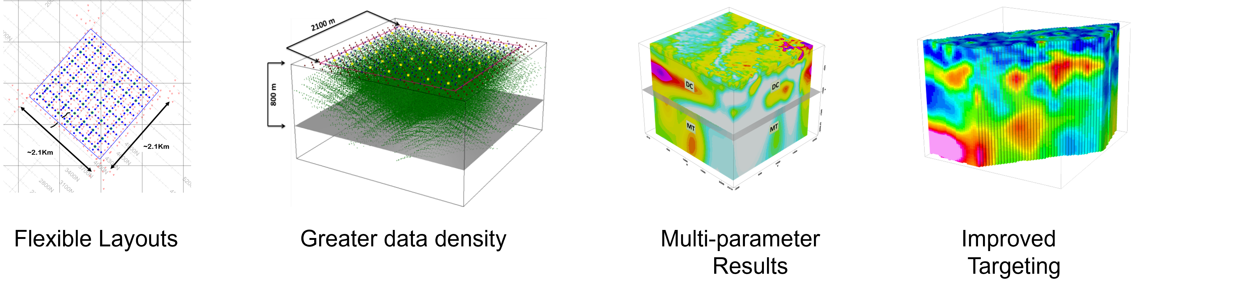
An ORION 3D survey, covering an area of 4 sq km, can be completed in only 3 weeks and provides the most sophisticated electrical imaging of the subsurface possible. There are virtually no limitations to the configuration of an ORION 3D survey. A survey covering an area of roughly 2 km x 2 km will provide deep 3D information to a depth of 2 km. 
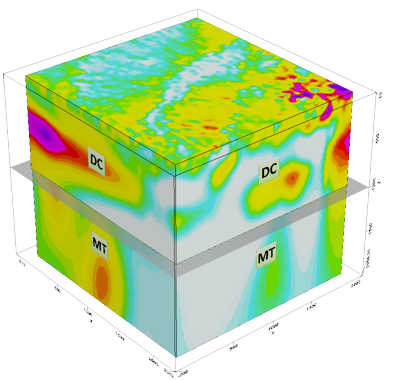
What is ORION 3D ?

ORION is a highly flexible 3D ground geophysical survey that can mobilise anywhere, is unlimited by terrain and other surface conditions, and is perfectly suited to explore in sensitive areas.  ORION 3D collects three sets of data in multi-directions – DC Resistivity, IP (induced polarization) to depths of 800 m, and deep MT resistivity to depths greater than 2000 metres. ORION 3D is the leading REAL 3D ground geophysical survey. The design of the survey allows for complete omni-directional coupling with geology, structure and mineral systems in the subsurface. This ability to measure in all possible directions means the system provides information on all possible orientations of subsurface structure and mineralisation. 3D surveys have no imaging bias imposed by survey geometry as can occur with traditional 2D.

Quantec’s ORION 3D technology collects data along multiple lines and in multiple directions. The system collects more than 200,000 data points per survey. With more data and omni directional data the derived 3D images offer thorough exploration prior to drilling.

ORION 3D uses core features developed through the evolution of the TITAN 24 system.

  • Full time series data acquisition for processing optimisation and noise cancellation
  • All transmitter signal is recorded and subsequently exactly removed from the recorded data (does not occur in traditional acquisition routines)
  • Telluric cancellation available for IP


How it works

Independently distributed receivers offer maximum flexibility for ORION 3D survey layout and design. A grid of receivers, which are responsible for a variety of functions are deployed in a grid.

For the IP survey the current is then deployed throughout the grid. Each current deployment (injection) is received across the whole grid by all the receiver dipoles at once. The current moves throughout the grid until full coverage has happened. The DCIP is collected during the day and the MT is completed the same night, thereby providing rapid data collection across the grid patch.

Conceptual current paths for only 2 current injections

Quantec RT 130 or 160 DAU can be distributed in different sized grids or random patterns for difficult access

All surveys are scaleable to your objectives


Flexible survey design

Setup  is completely flexible. Depending on target area of exploration as many individual data receiver module units as required can be deployed over an arbitrary 3D grid geometry

  • Flexible layouts optimised to each target/objective
  • Dipole lengths from 300 m to 50 m
  • Current injections throughout the grid
  • Rapid survey acquisition
  • Ability to provide 2D profiles as the survey progresses
  • Survey plan includes estimate of 3D coverage
  • Simultaneous measurements at distributed receivers for every current injection
  • Orthogonal receiver dipoles deployed across the entire survey area

Typical survey plan


Some survey results

Hidden Hill Gold occurrence

The ORION 3D DCIP & MT survey successfully mapped and characterised the known Hidden Hill mineralisation zone. This provided confidence in targeting during further follow-up on the Golden Arrow property.

3D Resistivity_Drillholes

 High resistivity iso-shells with confirmed drill results accurately mapped to 700 m.

Santa Cecilia Porphyry system, Chile

The animated slides seen below show how the ORION 3D layout is completely flexible, covering the whole mountain top. The 3D point data accumulated from the survey provided 3 parameters which included DC resistivity, IP and MT. 3D models were created utilising 3D inversion providing excellent imaging of the DC and IP down some 800m and the deeper MT down to 2000 metres. Not only are near surface to moderate depth targets revealed by the DC resistivity and IP but the deeper MT resistivity provides excellent depictions of the deep root of the system.

  • Santa Cecilia, porphyry system, Northern Chile

  • 540 current transmits, 300 dipoles

  • 100 MT sites

  • 150,000 IP data points

  • 3D chargeability model

  • Improved interpretation

  • High volume of data points contribute to best possible 3D inversion and models of subsurface

  • 3D resistivity model

  • High resolution imaging to depth

  • 3D resistivity data volume and model

  • Resistivity model can be sliced and diced for best practice interpretation

  • Deep MT survey highlights the root of the porphyry system

Kitumba, Africa, IOCG in the Copper Belt

Deep chargeability 3D Model results from ORION 3D survey shows depth to roughly 800 metres.

Note: excellent correlation with known sulphide horizon and barren holes drilled prior to the survey.

Consider an ORION 3D survey before your next significant drilling campaign. ORION provides several significant cost saving measures along with an increased likelihood of discovery and success.

Improve drill planning

  • True 3D data acquisition to avoid uncertainties in the early stages of resource development. Know the size, shape (volume), vertical and lateral extent of the resource for greater certainty of results. So you know where to drill next or whether a property is worth further investment.
  • Present better drill results for financing. Accurate imaging of  the subsurface will impact drill success in highly prospective regions.  It will be easier to secure financing for further development.
  • Drill more effectively. High-resolution data acquired in multi-directions gives you better detail than any other survey in the world. A complete picture before drilling helps you avoid unnecessary drill holes while focusing efforts on the most prospective targets.

Quantec’s geophysical experts custom design each survey to overcome the challenges of your site and to give you the best possible view of your resources on the surface and to depth.

Talk through your project and data with world-travelled geophysicists. Call or email to ask Quantec geophysicists to look at your data set.

 DOWNLOAD BROCHURE

or

REQUEST a QUOTE