Regional gravity survey, Zacatecas Mexico
Title: Deposit characterisation and regional studies
Geology: VMS environment
Client: Teck Resources
Technology: Gravity
Location: Mexico
Sector: Mining
Challenges
Teck wanted to characterise the San Nicolás discovery, to create a template vectoring tool that would lead to other discoveries on a regional scale.
Solutions
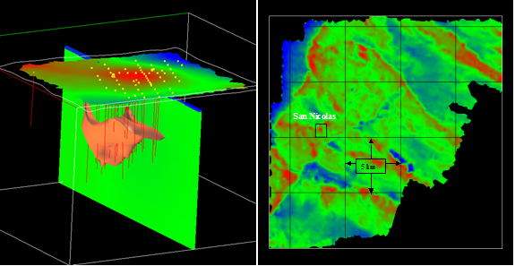
Given the large density contrast between the San Nicolás ore (approximately 3.4 to 4.7 g/cc) and the surrounding country rock (approximately 2.4 to 2.7 g/cc), it was decided to conduct a detailed gravity survey over the deposit. Successful delineation of the ore body with gravity could then lead to a regional gravity survey to further explore for potential San Nicolás style VMS deposits.
Various 2D FFT filters and optimal filter imaging were applied to the San Nicolás gravity data. The first vertical derivative map of the survey is shown in Plate 1b above. The first vertical derivative is applied to the gravity data to enhance the response at shallow to moderate depths to density variations in the earth.
Highlights
This data set clearly outlines the San Nicolás deposit as a strong, first vertical derivative high (red), circular anomaly. The detailed survey results over the San Nicolás deposit showed a circular, 1.0 to 1.5 km wide Bouguer gravity high (red). The anomaly had a peak response of approximately 3 milligals and was centered over the San Nicolás ore zone. Further 3-D modeling of the gravity data using geology from existing drill holes as constraints is seen in figure above.
Given the success of the detailed San Nicolás gravity survey, a regional survey was then conducted over approximately 300 square kilometers. The Bouguer gravity data from this survey spanned almost 22 milligals in amplitude.
Other structural and lithologic contact features are also obvious on the map in predominantly NW-SE and NE-SW strike directions. The program successfully provided follow up exploration targeting.

