NOA Lithium Brines Completes CSAMT Survey and Significantly Increases Mineral Resource Estimate by 65% At Rio Grande Project
Mr. Gabriel Rubacha reports:
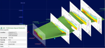
BUENOS AIRES, ARGENTINA / ACCESSWIRE / May 29, 2024 /NOA Lithium Brines Inc. (TSXV:NOAL)(FSE:N7N) (“ NOA ” or the “ Company “) is pleased to announce the completion of a Controlled Source Audio-Magnetotelluric (“ CSAMT “) survey and update of its NI 43-101 resource technical report (“ Technical Report “) for its Rio Grande Project. Montgomery and Associates updated the resource estimate based on the CSAMT which confirmed low conductivity areas corresponding to lithium saturated brines in the southeast area of NOA’s Rio Grande properties, adding 1,509,000 tonnes of Lithium Carbonate Equivalent (“ LCE “) of Inferred resource with a concentration estimated at 450 milligrams per litre (“ mg/l “), for an aggregate Measured, Indicated and Inferred Mineral Resource Estimate (“ MRE “) of 3,799,000 tonnes of LCE with an average estimated concentration of 535 mg/l.
Highlights from the results of the program include:
CSAMT Survey : The CSAMT survey consisted of 20 lines with an average line spacing of 1,500 meters at the Rio Grande project.
Significant Resource Expansion: There has been a significant increase in Inferred resources to 1,880,000 Mt of LCE, from 371,000 Mt of LCE previously, resulting in an increase of 407%.
Revised Mineral Resource Estimate: The new Rio Grande MRE contains a total resource of 3.8 million tonnes @ 535 mg/l, resulting in an increase of 65% compared to the prior MRE dated February 26, 2024.
Upside Potential: Certain property areas in the north and northeast of the Rio Grande Project may be subject to a change in category from indicated to measured and from inferred to indicated.
North Properties: A resource estimate on the northern properties of the Rio Grande Project may be increased as further expanded to the west.
Quantec Geoscience Argentina S.A. conducted the CSAMT study completing and surveying most of the properties contained in the Rio Grande Project.
The main objective of the study included the identification of areas to be explored as part of our second stage drilling campaign, which is planned to begin during 2024. This second stage drilling program will include additional diamond drilling in unexplored properties, drilling of pumping wells close to existing diamond drilled holes, and industrial water exploration and process engineering which will lead to our planned Preliminary Economic Assessment on the Rio Grande Project.
Conductive brine material highlighted by CSAMT
About Quantec Geoscience Argentina S.A.
Quantec Geoscience is a recognized leader in the industry, with experience over 40 countries with and extensive experience in the provision of geophysical services for the evaluation of salars in lithium prolific areas of Argentina.
Cascadia Samples 9.01% Copper and Prepares for 2024 Diamond Drilling at PIL Property, British Columbia
January 9, 2024
January 9, 2024 – Vancouver, BC – Cascadia Minerals Ltd. (“Cascadia”) (TSX-V:CAM) is pleased to provide results of the 2023 exploration program at the PIL Property, located in the prolific Toodoggone porphyry copper-gold and epithermal precious metals district of northern British Columbia, Canada. Work in 2023 included a TITAN deep induced polarization (“IP”) geophysical survey at the PIL South target, as well as prospecting and mapping focused primarily in the underexplored northeastern portion of the property, at the Spruce target.
PIL 2023 Exploration Summary
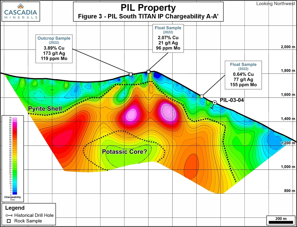
Deep IP survey at the PIL South target identified a classic porphyry signature below shallow historical drilling that intersected typical high-level pyrite mineralization and alteration;
The IP survey signature underlies a 2.5 x 2.0 km gold-copper ± molybdenum soil and rock sample anomaly at surface;
Prospecting at the Spruce target identified significant copper, silver and molybdenum samples along a 2.6 km trend;
Spruce rock sample highlights include 9.01% copper with 212 g/t silver and 0.26 g/t gold in float, and 3.75% copper with 101 ppm molybdenum in outcrop; and
Planning is underway for 2024 exploration, including diamond drilling at PIL South in 2024 to test the porphyry target at depth and geophysics and mapping to prepare Spruce for drilling.
“We are very encouraged by the deep IP survey at the PIL South target as it returned compelling indications of porphyry copper mineralization at depth, beneath historical shallow drilling. We plan to undertake our first diamond drill program at PIL this summer, focusing on testing PIL South at depth,” said Graham Downs, Cascadia’s President and CEO. “The prospecting results from the recently identified Spruce target are also very exciting. We have now defined a 2.6 km mineralized trend in this area with alteration profiles suggestive of porphyry mineralization. We will continue to systematically advance Spruce in 2024, with geophysics, surface work, and drilling if warranted.”
A TITAN deep IP geophysical survey was conducted at the PIL South target in 2023, in an area with strong surface mineralization, limited historical drilling, and a strong response from a shallower conventional IP survey completed in 2022. Two perpendicular TITAN IP lines were completed, totaling 4.8 line-km (Figure 2).
Results of this survey are suggestive of the potential for a buried porphyry target underneath the shallow historical drilling. The chargeability response exhibits a broad zone of very high-chargeability around a deeper zone of moderate chargeability, suggestive of a pyrite halo around the core of a porphyry system (Figure 3) at the 1,200 m elevation level. The resistivity response shows a core zone of moderate resistivity with moderate chargeability values that could represent the potassic core (Figure 4).
Three shallow historical drillholes were completed by a previous operator at this target in 2003, with no significant intercepts of copper mineralization. Core from these holes were reviewed in detail this season and exhibits high-level alteration signatures (propylitic to sericite alteration), as well as zones of significant pyrite, and short intervals of anomalous copper and gold. This supports the interpretation of the IP signature, suggesting the presence of a pyrite shell – intersected by historical drilling – potentially adjacent to the potassic core of a porphyry that has never been drill tested.
Cascadia plans to drill-test this hypothesized potassic core in 2024, embarking on its first diamond drilling campaign at the PIL property.
Prospecting and Mapping Results
Fieldwork in 2023 included the collection of 420 soil samples and 186 rock samples. Exploration was focused on the Spruce and PIL South areas, with expansion of soil grids at both targets (Figure 1). Contour sampling and prospecting was also completed in various underexplored areas between the two targets.
Rock sampling at Spruce identified mineralization in float and outcrop across a 2.6 km trend northwest of the original 2022 discovery outcrop, in an area that has seen no historical exploration. Grab samples returned results including 3.75% copper with 101 ppm molybdenum in outcrop, 2.07% copper in outcrop, and 9.01% copper with 212 g/t silver and 0.26 g/t gold in talus (Figure 5). The alteration assemblage and trace element signature of samples in this area are strongly suggestive of porphyry style mineralization at depth. Given the extensive nature of mineralization at Spruce, planning is underway for follow-up work in 2024.
Soil sampling results extended the known PIL South anomaly further to the east, and identified a new area of potential mineralization 3 km south of the Spruce target (Figure 1). These areas will be further evaluated in 2024.
Property Geology and Mineralization
The 151 km2 PIL Property is located in the heart of the 90 x 20 km northwest-trending Toodoggone district in northern British Columbia, within the eastern part of the Stikine Terrane. The Stikine Terrane is juxtaposed against the Quesnel Terrane by the 1,000+ km long, deep seated, crustal scale strike-slip Teslin-Thibert fault approximately 8 km northeast of the property boundary. Stikine and Quesnel Terranes are characterized by similar Late Triassic to Early Jurassic volcanic-plutonic arc complexes that host numerous porphyry copper-gold-molybdenum mines, deposits and prospects including Red Chris (Newmont Mining), Galore Creek (Teck/Newmont), Kemess (Centerra Gold), and Mount Milligan (Centerra Gold). Numerous epithermal gold-silver projects are also found in the region, including Brucejack (Newmont Mining), Ranch (Thesis Gold) and Lawyers (Thesis Gold).
The Toodoggone district is underlain by volcanic and sedimentary rocks of the Early to Middle Jurassic Hazelton Group and the coeval Early Jurassic Black Lake Plutonic intrusive complex. There is a prominent northwest-trending regional structural fabric with the strata in the Toodoggone disrupted by several steeply dipping normal faults, strike-slip faults and thrust faults.
The Property is under option from Finlay Minerals Ltd., and Cascadia has the ability to acquire a 70% interest in the project by making a series of staged payments and work expenditures. For more details on the Property, please visit our website at www.cascadiaminerals.com.
About Cascadia
Cascadia is a Canadian junior mining company focused on exploring for copper and gold in the Yukon and British Columbia. Cascadia’s flagship Catch Property in the Yukon hosts a brand-new copper-gold porphyry discovery where inaugural drill results returned broad intervals of mineralization, including 116.60 m of 0.31% copper with 0.30 g/t gold. Catch exhibits extensive high-grade copper and gold mineralization across a 5 km long trend, with rock samples returning peak values of 3.88% copper and 30.00 g/t gold.
In addition to Catch, Cascadia is conducting exploration work at its PIL Property in British Columbia and the Sands of Time and Rosy properties in the Yukon, as well as evaluating additional regional opportunities. Cascadia has approximately 37 million shares outstanding and its largest shareholders are Hecla Mining Company (19.6%) and Barrick Gold (7.5%).
QA/QC
Analytical work for samples was completed by ALS Canada Ltd., with sample preparation in Kamloops, BC, and geochemical analyses in North Vancouver, BC. Rock samples were fine crushed before a 250-gram split was pulverized to better than 85% passing 75 microns. Gold was determined for core samples by the Au-AA23 procedure which involves fire assay preparation using a 30-gram charge with an atomic absorption spectroscopy finish. Multi-element data for 48 elements was determined for by the ME-MS61 procedure, which involves a four-acid digestion followed by inductively couple plasma-atomic emission spectroscopy (“ICP-AES”) and inductively coupled plasma-mass spectrometry (“ICP-MS”). Overlimit values for copper, silver, lead and zinc were determined using the ME-OG62 procedure, which involves a four-acid digestion followed by ICP-AES analysis.
Soil samples were dry-screened at 180 micron, with analysis conducted on the fine fraction. Soil samples were analyzed for gold and 50 other elements by the AuME-TL43 procedure which involves aqua regia digestion of a 25-gram split with an ICP-AES and ICP-MS finish.
Results referenced in this release represent highlight results only. Below detection values for gold, silver, copper, lead, zinc and molybdenum have been encountered in drilling, rock and soil samples in these target areas.
The technical information in this news release has been approved by Adam Coulter, M.Sc., P.Geo., VP Exploration for Cascadia and a qualified person for the purposes of National Instrument 43-101.
On behalf of Cascadia Minerals Ltd.
Graham Downs, President and CEO
For further information, please contact:
Andrew Carne, M.Eng., P.Eng., VP Corporate Development
Cascadia Minerals Ltd.
T: 604-688-0111 ext. 106 acarne@cascadiaminerals.com
https://quantecgeo.com/wp-content/uploads/2024/01/Pil-ip.jpg7651000Webmasterhttp://quantecgeo.com/wp-content/uploads/2023/03/Quantec-Official-2017-Logo-clear-Horizontal.pngWebmaster2024-01-15 20:46:092024-04-19 16:07:27Cascadia - Deep TITAN IP survey at the PIL South target identified a classic porphyry signature
Copper Fox Announces Positive IP Results and Increases Land Position at Mineral Mountain Copper Project
November 22, 2023
Calgary, Alberta–(Newsfile Corp. – November 22, 2023) – Copper Fox Metals Inc. (TSXV: CUU) (OTCQX: CPFXF) (“Copper Fox” or the “Company”) and its wholly owned subsidiary, Desert Fox Mineral Mountain Co., are pleased to announce the results of the deep penetrating geophysical survey utilizing Quantec’s ORION 3D Swath DCIP configuration on its 100% owned Mineral Mountain project (the “Project”) located approximately 16 miles northeast of Florence, Arizona. Highlights of the survey are set out below:
Highlights
A northeast trending open-ended positive (>18mrad) chargeability/resistivity anomaly measuring approximately 3,200 meters (‘m’) long by 1,200 m wide has been identified.
The chargeability/resistivity signature is like that which would be expected in the oxidized/supergene zone above the hypogene zone of a porphyry copper system in Arizona.
A 1,200 m long by 900 m wide portion of the larger chargeability/resistivity anomaly comes to surface in an area of the property with quartz vein/veinlet/fracture hosted secondary copper (chrysocolla, malachite, chalcocite) and molybdenum mineralization in sericitic/potassic altered porphyritic quartz monzonite and granodiorite.
An additional 80 mineral claims (1,653 acres) have been added to the Project to cover the interpreted extension of the northeast trending open-ended positive chargeability/resistivity anomaly and a mineralized Laramide intrusive.
Elmer B. Stewart, President, and CEO of Copper Fox, stated, “The results of the IP survey are consistent with the current geophysical model for the oxidized/supergene enriched portion of a Laramide age porphyry copper system in Arizona. The strong positive correlation between the various geoscientific data has identified a near surface drillable target measuring approximately 1,200 m long and 900 m wide that transitions at depth to a significantly larger chargeability signature consistent with the geological/exploration model developed for the Mineral Mountain project.”
Geological Model The Mineral Mountain project covers a copper-gold-molybdenum porphyry system characterized by a copper-magnetite mineral association that has been subjected to weathering/oxidization/supergene enrichment, a process commonly observed at porphyry copper systems in Arizona. The porphyry copper deposits in the Safford and Ajo Mining Districts of Arizona are being used as geological/exploration models for the Project. The porphyry copper footprint at Mineral Mountain is located on the eastern side of the Laramide intrusive and is interpreted to dip to the east and to the north under the PreCambrian rocks consistent with the location of the recently defined chargeability signature.
Geophysical Study Recent investigation of the geophysical characteristics of porphyry copper systems in Arizona shows that the oxidation/supergene processes that affected these porphyry copper systems have altered the petrophysical properties of the mineralization and host rock resulting in lower chargeability and increased resistivity signatures within the oxidation/supergene zone of porphyry copper deposits. Source:Howe, B, Devriese, Sarah, G.R., March 2023; An Empirical Geophysical Model for Porphyry Copper deposits in the Laramide Copper Province.
The 2023 geophysical survey has outlined a northeast trending open-ended 3,200 m long by 1,200 m wide chargeability (+18mrad contour) anomaly. Based on the +15mrad chargeability contour, the western, southern, and southeast edges of the anomaly have been defined. The anomaly remains open to the northeast.
Figure-1: The +/-350 m below surface 3D model of the northeast trending open-ended anomaly showing the +15mrad and +18mrad chargeability signatures and recently staked mineral claims.
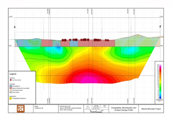
The 1,200 m long by 900 m wide chargeability/resistivity signature that comes to surface in an area of the property that contains abundant mineralized porphyry style quartz veins/veinlets and fractures containing secondary (chrysocolla, malachite, chalcocite) copper and molybdenum mineralization hosted primarily in sericitic and to a lesser degree potassic altered phases of the Laramide age intrusive. The lower chargeability/increased resistivity signature is similar to the recent geophysical model of Laramide age porphyry copper deposits in Arizona. Figure-2 and Figure-3 show the chargeability and resistivity pseudo sections for L-2000 that crosses the 1,200 m by 900 m chargeability/resistivity anomaly. The strength of the chargeability signature increases with depth and is interpreted to represent the primary hypogene sulphide zone of a porphyry system.
Figure-2: L-2000 chargeability pseudo section, Mineral Mountain project.
Rationale for Land Acquisition The Mineral Mountain project is located within a northeast trending, regional scale, porphyry copper belt that extends from the Ajo porphyry copper district in the west to the Miami-Globe porphyry copper district in the east and hosts some of the largest porphyry copper deposits in Arizona including Santa Cruz and Resolution. The Project is located approximately 25 kilometers (‘km’) east of Florence, Arizona between the Florence and Resolution porphyry copper deposits.
The recently acquired lands covers:
Four Laramide age quartz monzonite plugs and several Tertiary age porphyritic granodiorite dikes, interpreted to represent the continuation of the Mineral Mountain intrusive complex to the northeast.
The results of the 2023 geophysical survey indicate that the chargeability/resistivity anomaly associated with the copper mineralization at Mineral Mountain extends to the northeast into the recently acquired mineral claims.
The largest of the quartz monzonite plugs host extensively oxidized/leached porphyry style quartz veins, quartz veinlets and fractures containing secondary copper minerals (chrysocolla, malachite, chalcocite) and molybdenite.
The 2022 airborne magnetic and radiometric survey identified a buried positive magnetic feature interpreted to represent a potassic altered (due to magnetite) late stage intrusive underlying the largest Laramide age intrusive.
Geophysical Survey Procedures The ORION 3D SWATH DCIP survey completed by Quantec Geoscience USA Inc. was centered over the Laramide intrusive and measured (employing a pole-dipole array configuration) the DCIP signal on 9 survey lines. The survey mesh covered an area of approximately 3.2 km x 3.6 km using a 25 m cell size in the X and Y directions to cover the electrode array zone (core mesh). Padding cells covering ~3.35 km in each horizontal direction were added to extend the core mesh. A homogenous half-space of ~ 750 ohm-m was used as a starting model for DC inversion. The IP inversions were completed with use of the sensitivity matrix calculated from the calculated 3D conductivity model.
The 2D DC and IP inversions were carried out using the UBC DCIP2D inversion codes (Oldenburg and Li, 1994) to produce depth sections of DC resistivity, DC-referenced IP chargeability and HS-referenced IP chargeability to a depth of investigation of 750 m to 800 m. The 3D inversion of the DC and IP data was completed using the UBC 3D inversion codes (Li and Oldenburg, 2000). The full set of 3D Tx-Rx measurements were merged into a single data set and modeled in 3D to produce 3D resistivity and DC-referenced chargeability models.
Elmer B. Stewart, MSc. P. Geol., President and CEO of Copper Fox, is the Company’s non-independent, nominated Qualified Person pursuant to National Instrument 43-101, Standards for Disclosure for Mineral Projects, and has reviewed and approves the scientific and technical information disclosed in this news release.
About Copper Fox Copper Fox is a Tier 1 Canadian resource company focused on copper exploration and development in Canada and the United States. The principal assets of Copper Fox and its wholly owned subsidiaries, being Northern Fox Copper Inc. and Desert Fox Copper Inc., are the 100% ownership of the Van Dyke oxide copper project located in Miami, AZ, the 100% interest in the Mineral Mountain and Sombrero Butte porphyry copper exploration projects located in Arizona, the 25% interest in the Schaft Creek Joint Venture with Teck Resources Limited on the Schaft Creek copper-gold-molybdenum-silver project and the 100% owned Eaglehead polymetallic porphyry copper project each located in northwestern British Columbia. For more information on Copper Fox’s mineral properties and investments visit the Company’s website at http://www.copperfoxmetals.com.
On behalf of the Board of Directors
Elmer B. Stewart
President and Chief Executive Officer
https://quantecgeo.com/wp-content/uploads/2024/01/cf-nov-ip.jpg389550Webmasterhttp://quantecgeo.com/wp-content/uploads/2023/03/Quantec-Official-2017-Logo-clear-Horizontal.pngWebmaster2024-01-15 20:16:292024-04-19 16:07:27Copper Fox Announces Positive IP Results and Increases Land Position at Mineral Mountain Copper Project
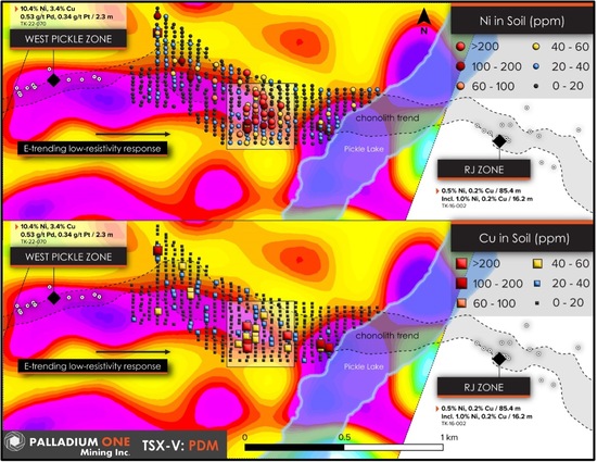
October 30, 2023 – Toronto, Ontario – Palladium One Mining Inc. (TSX-V: PDM, OTCQB: NKORF, FRA: 7N11) (the “Company” or “Palladium One”) is pleased to announce it has discovered a large MT resistivity anomaly on the Tyko I property (Figure 1 and 2) which forms part of the larger Tyko Nickel – Copper Project, in Ontario, Canada. The MT resistivity anomaly is coincident with the high-grade West Pickle Zone and extends eastward toward the RJ Zone suggesting that they form one continuous mineralizing system.
Highlights
2023 diamond drill program is underway at Tyko
A 1,600 meter long MT resistivity anomaly has been discovered which extends from the high-grade West Pickle Zone toward the interpreted Chonolith / Feeder Dyke structure
MT Anomaly coincident with multiple Cu and Ni in soil anomalies
Mag, MT and soil anomalies suggest West Pickle and RJ Zones form part of one large mineralizing system
President and CEO, Derrick Weyrauch commented, “We are very pleased to announce positive results from the first MT survey on the Tyko Project that indicate a strong MT resistivity anomaly extending from our high-grade West Pickle zone toward multiple copper and nickel in-soil anomalies associated with the interpreted Chonolith / Feeder Dyke target. Tyko’s fall diamond drill program has commenced and is currently on track.”
The MT survey represents the first deep penetrating geophysical survey to be conducted on Tyko. The survey was undertaken by Quantec Geoscience using the SPARTAN MT system which has the potential to detect both high-grade massive nickel sulphide, as that found at the West Pickle zone, and blebby to disseminated sulphide as found at the RJ zone. The MT survey targeted a highly prospective strike length of 2,800 meters (Figure 2) between the West Pickle and RJ Zones covering several highly anomalous Cu and Ni soil anomalies and associated magnetic highs (see press release August 22, 2023).
https://quantecgeo.com/wp-content/uploads/2023/11/Paladium-One-MT-oct-23.jpg425550Webmasterhttp://quantecgeo.com/wp-content/uploads/2023/03/Quantec-Official-2017-Logo-clear-Horizontal.pngWebmaster2023-11-01 13:50:092024-04-19 16:07:27Palladium One Outlines MagnetoTelluric "MT" anomaly at West Pickle, Drill Program Underway on Tyko Ni - Cu Project
Juggernaut Exploration Commences Drilling on Midas Property
Mr. Dan Stuart reports:
Vancouver, British Columbia – TheNewswire – July 18th, 2023 – Juggernaut Exploration Ltd (TSXV:JUGR) (OTC:JUGRF) (FSE: 4JE) (the “Company” or “Juggernaut”) is pleased to report drilling has commenced on its 100% controlled Eskay Style VHMS Midas property. The Company has a total of ~4,500 meters of drilling planned on Midas in world class geologic terrane all with strong discovery potential. Midas consists of 20,803 hectares and is located 24 km southeast of Terrace, British Columbia in close proximity to logging access roads, power, railway and major infrastructure.
The Midas property is located in an area of recent glacial abatement and permanent snowpack recession at the southern end of the Golden Triangle, British Columbia. Multiple high-grade gold grab, chips and channel samples were collected from the Kokomo VHMS target where a 1.00 m chip sample assayed 9.343 gpt Au, 117 gpt Ag, 1.58 % Cu and 1.77 % Zn and is drill ready. Relatively shallow Induced Polarization (IP) chargeability and resistivity anomaly extends under the Kokomo showing on trend to the south for at least 850 meters towards the VG Zone, conducive for a buried VHMS containing semi-massive to massive sulphides at depth. Channel samples highlights from the VG Zone include 10.28 gpt Au over 4.34 meters; 15.37 gpt Au over 2 meters; and 5.43 gpt Au over 3.11 meters. Historic drill results from the Midas property include hole MD-18-16 which intersected the peripheral zone of the IP anomaly core and returned 0.56 g/t AuEq over 35.35 meters; hole MD-18-08, which assayed 6.85 gpt Au over 9 meters and narrowly missed a strong IP chargeability anomaly; and hole MD-18-01 which intersected 3.27 gpt AuEq over 4.80 meters and ended before it reached the core of a strong IP chargeability anomaly.
Midas 2023 Planned Drill Holes Targeting IP anomaly
A series of 5 drill targets have been identified in association with the surface mineralization and the subsurface geophysical IP data on the Midas property along the 850 meter south trending anomaly connecting the Kokomo target with the VG Zone. These targets are being drill tested with ~4,500 meters of drilling from 7 pad locations.
Midas 2023 Planned Drill Holes Targeting IP anomaly
Highlights from the Midas property:
Historic drill results from the Midas property include hole MD-18-16 which intersected the peripheral zone of the IP anomaly and returned 0.56 g/t AuEq over 35.35 meters; hole MD-18-08, which assayed 6.85 gpt Au over 9 meters and narrowly missed a strong IP chargeability anomaly core; and hole MD-18-01 which intersected 3.27 gpt AuEq over 4.80 meters and ended before it reached the core of a strong IP chargeability anomaly.
Channel samples highlights from the VG Zone include 10.28 gpt Au over 4.34 meters; 15.37 gpt Au over 2 meters; and 5.43 gpt Au over 3.11 meters.
Multiple high-grade gold grab, chips and channel samples including Kokomo showing where a 1 m chip sample assayed 9.343 gpt Au, 117 gpt Ag, 1.58 % Cu and 1.77 % Zn.
Relatively shallow Induced Polarization (IP) chargeability and resistivity anomaly extends under the Kokomo showing for at least 850 meters on trend to the south conducive for semi-massive to massive sulphides.
Alteration zones extracted from Worldview 3 satellite spectral data show a strong silica, iron and phyllic alteration (quartz-sericite-pyrite) signature overlapping the Kokomo showing and the 850-meter trend immediately to the south and east coinciding with the IP anomaly in the subsurface, further indicating the presence of a mineralized VHMS system at depth.
Regional and local geology is highly prospective for VHMS deposits including the presence of a rhyolitic tuff with strong phyllic alteration (quartz-sericite-pyrite) from the Mt Attree volcanics which are Mississippian in age. Mississippian age rocks are known to host the majority of significant VHMS deposits.
Widespread Zn signature with secondary Au, Ag, Pb, Cu and trace element signature (elevated Au, Te, As, Sb, Bi, Cd, Hg, Ba).
Midas is within a world class geologic setting with strong potential for Eskay-style VHMS mineralization.
Dan Stuart, President and CEO of Juggernaut Exploration states “We are excited to begin drilling on Midas. We designed what we believe is a strong drill plan for the High-Grade Gold targets with world class discovery potential in areas that have not been drill tested before. The planned program that consists of ~4,500 meters of drilling on Midas has commenced early this year due to exceptionally good weather across Northwestern B.C. With much anticipation, we look forward to reporting results. Furthermore, drilling is imminent on both the Bingo property hosted in the same world-class geological units as Goliath Resource’s Surebet discovery next door and the Empire property where outcrop assayed up to 36,875 gpt Ag (1180 ounces per ton silver), 4.68 gpt Au, 27.6% Cu and 3.27% Zn (This is one of the highest silver samples collected from outcrop in Canadian history).”
Qualified Person
Rein Turna P. Geo is the qualified person as defined by National Instrument 43-101, for Juggernaut Exploration projects, and supervised the preparation of, and has reviewed and approved, the technical information in this release.
Drilling Intersects a 55.4m Sulphide Zone at Lynn Lake Nickel Project
Success in the first drill hole testing a newly identified pipe-like geophysical anomaly at the priority Fraser Lake Complex
Key Highlights
Innovative geophysical survey defined several pipe-like conductive bodies linking
into areas of drill-defined nickel-copper-cobalt sulphide mineralisation within the
Fraser Lake Complex at Lynn Lake.
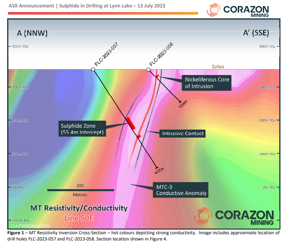
The initial drill hole of a two-hole program testing one of these anomalies
intersected a 55.4 metres (downhole) sulphide zone on the margin of an interpreted
mafic/ultramafic intrusive pipe.
The targeted geophysical anomaly extends from near surface to at least 700 metres
below surface.
Samples have been submitted for laboratory analysis with results to be released
when available – further drilling planned, subject to results.
Corazon’s Managing Director, Mr. Brett Smith, stated: “The most significant outcome from this drilling is proving that
our new geophysical techniques can identify the targeted magmatic sulphides, as well as these late, metal-rich
ultramafic pipes.
https://quantecgeo.com/wp-content/uploads/2023/07/Corazon-MT-image.png794924Webmasterhttp://quantecgeo.com/wp-content/uploads/2023/03/Quantec-Official-2017-Logo-clear-Horizontal.pngWebmaster2023-07-19 17:17:152024-04-19 16:05:33Corazon Intersects a 55.4m Sulphide Zone
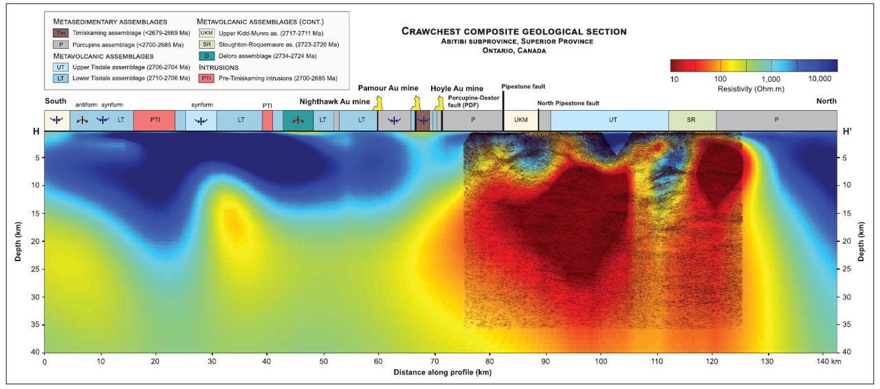
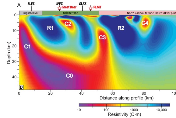
Newly released paper discusses MT applications and implications in the Red Lake Greenstone belt following Metal Earth initiative using SPARTAN MT .
Crustal conductivity footprint of the orogenic gold district in the Red Lake greenstone belt, western Superior craton, Canada
Ademola Q. Adetunji1, Gaetan Launay1, Ian J. Ferguson2, Jack M. Simmons1, Chong Ma1, John Ayer1 and Bruno Lafrance1
1Mineral Exploration Research Centre (MERC), Harquail School of Earth Sciences, Laurentian University, Sudbury, ON P3E2C6, Canada
2Department of Earth Sciences, University of Manitoba, Winnipeg, MB R3T2N2, Canada
ABSTRACT
A magnetotelluric (MT) study across the Red Lake greenstone belt of the western Superior craton, Canada, images a 50-km-long north-dipping conductor (<20 Ω·m) at 20–25 km
depth and subvertical conductors spatially correlated with crustal-scale shear zones and
large orogenic gold deposits. The conductors are interpreted to be the conductivity signature
of the deep crustal source of the auriferous fluids and pathways of the orogenic gold system. The geophysical results, supported by existing geochemical and fluid inclusion studies,
suggest that the Au- and CO2-rich fluids responsible for gold mineralization were released
by devolatilization of supracrustal rocks underthrust to mid- to lower-crustal levels during
subduction. This MT study links shallow gold mineralization to a deep crustal source region,
demonstrating the connection between a crustal suture zone and the formation of orogenic
gold deposits in an Archean greenstone belt.
https://quantecgeo.com/wp-content/uploads/2023/03/Red-lake-fingers.jpg390578Webmasterhttp://quantecgeo.com/wp-content/uploads/2023/03/Quantec-Official-2017-Logo-clear-Horizontal.pngWebmaster2023-03-13 20:10:462024-04-19 16:05:20Spectacular MT results under Red Lake
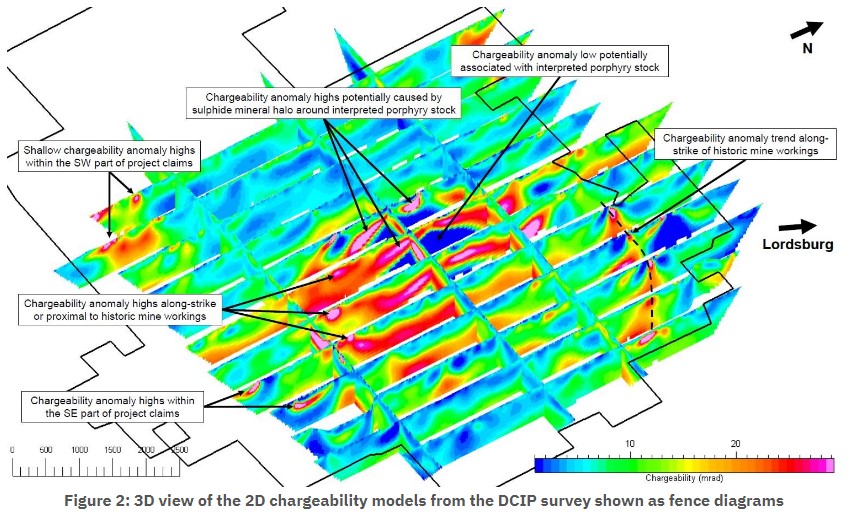
Vancouver, British Columbia–(Newsfile Corp. – January 18, 2023) – American Copper Development Corporation(CSE: ADCX) (“ACDC” or the “Company”) is pleased to report preliminary results from a 134 line-km 3D Titan 160 DC resistivity/induced polarization (DCIP) and Magnetotellurics (MT) survey. The survey was completed across 16 lines (13 N-S and 3 E-W) by Quantec Geoscience over the Company’s flagship Lordsburg property in southwestern New Mexico (see map in appendix).
The purpose of the survey is to provide property-wide deep chargeability, resistivity, and magnetotelluric information at the Lordsburg property with the intent to help identify porphyry and/or skarn style mineralization targets. The DCIP provides information to depths of 700m and greater with the MT resistivity providing information to depths of up to 2km. Quantec conducted this high-resolution survey between August 2022 and January 2023. The Company is currently working with our contractors on 3D data inversions of both the DCIP and MT surveys and expect to have those results completed by February.
Minto Metals Reports Anomalies And New Exploration Targets From Magnetotellurics Survey
WHITEHORSE, YT, Dec. 20, 2022 /CNW/ – Minto Metals Corp. (“Minto” or the “Company”) (TSXV: MNTO) is pleased to report results from the 2022 Magnetotellurics survey over the Minto Mine Property.
The Company commissioned Quantec Geoscience Ltd. (“Quantec”) to conduct a SPARTAN MT survey, a deep-penetrating Magnetotellurics (“MT”) survey over the Minto Mine Property (Figure 1). The goal for the MT survey was to extend the geophysical coverage for the Minto Mine Property to depths below the extents of previous geophysical surveys, diamond drilling and current mining infrastructure to assess the potential for additional economic mineralization. Quantec completed the survey, consisting of a total of 184 SPARTAN MT sites (Figure 2), between July 10, 2022 and August 28, 2022 with results received by the Company in late November 2022.
Vancouver, BC / CNW / October 25, 2022 / Argentina Lithium & Energy Corp. (TSX-V: LIT, FSE: OAY3, OTC: PNXLF), (“Argentina Lithium” or the “Company”) reports positive lithium brine values from the third and fourth diamond drill holes at its Rincon West Project in Salta Province, Argentina. The Rincon West project covers 3742.8 hectares of the salar basin, located west and north of the adjacent Rincon Project owned by Rio Tinto. The property is currently permitted for up to 9 exploration drill holes. The fifth exploration hole is currently in final steps to completion. From May 2022 ….
“The TEM surveys suggest that interpreted brine aquifers extend substantially further west and south than indicated by earlier electrical surveys, demonstrating greater potential than expected by the previous owners. We plan to begin drilling in May to test these targets. These new geophysical data allow us to assess potential aquifer quality and depth prior to drilling, which is extremely advantageous for targeting.” stated Miles Rideout, V.P. of Exploration.
The TEM surveys, data modeling and presentation were completed by the Argentinean subsidiary of Toronto-based Quantec Geoscience Ltd., (“Quantec”). Quantec is a recognized leader in the industry, with experience spanning over 40 countries with over 5,000 geophysical projects. Quantec has considerable experience in the provision of qeophysical services for the evaluation of salars in the Puna Region of Argentina.
A total of 190 soundings were completed at 200 metre intervals along six east-west lines and two transecting lines, with a north-south line spacing of between 1400 and 1900 metres (see Figure 1). Data were acquired with a Geonics Ltd. PROTEM System operated in centre-loop sounding mode with 200m transmitter loops. The sounding data were recorded at 2.5 and 25 Hz. repetition rates. The data were modelled with 1-D resistivity-depth inversions, which were compiled as 2D resistivity transects of the project. The maximum depth of investigation varied from 200 metres to as much as 1700 metres below surface.