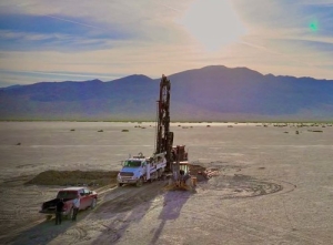
Drilling deep MT conductor
Title: Deep resistivity study
Geology: Kibby Basin
Client: Belmont Resources
Technology: SPARTAN MT
Location: Nevada, USA
Sector: Mining – Critical minerals
Challenges
Investigating large identified prospective terrain efficiently and cost effectively.
Key objectives of the survey were:
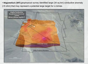
- Image the subsurface location and geometry of buried conductive features that may be related to lithium bearing clay horizons at depth.
- Map the basin to gain a better regional picture.
Solutions
SPARTAN MT is a robust and flexible means of covering large areas and highlighting resistivity structures within the subsurface to great depths. (surface to > 2km)
To assist large budget drill targeting decisions in a timely manner, a resistivity model to 5 km depth was required to provide a better understanding of the hydrothermal systems (e.g. size, depth and shape) present.
Highlights
Quantec’s team of leading MT experts provided deep imaging with the proprietary SPARTAN MT system. Plan maps created between 500m through to 3500m depth provided a geological model supporting the presence and location of deep conductive features potentially associated with flat lying brines. Key project objectives were met, subsequent drilling results confirmed the presence of Lithium horizons.
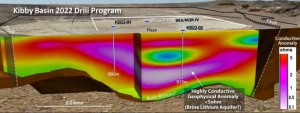
Deep MT resistivity model provided from SPARTAN MT survey
