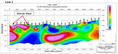
TORONTO, March 27, 2018 (GLOBE NEWSWIRE) — Lithium Energi Exploration, Inc. (TSXV:LEXI) (“LEXI” or the “Company”) is pleased to announce positive results from its initial geophysical surveys on each of the first three concessions studied in the northern section of its holdings in the Antofalla Salar.  Interpreted brine horizons were detected throughout the entire 80 km2 area of these concessions, inferring the possibility that lithium-bearing brine exists beneath the properties in the northern area of the Antofalla Salar. The survey results received to date indicate that conductive horizons have been detected from just below surface to as much as 400 meters in depth.

LEXI’s Director of Exploration, Miles Rideout, noted, “Having conducted or supervised the acquisition of thousands of kilometers of TEM soundings in brine environments over the last thirty years, I’m pleased to report that the initial geophysical results exceeded our expectations. The highly conductive units encountered correlate with known brine aquifers and these data allow us to follow these target zones under areas of thick cover.”


Vancouver, B.C. Canada, March 1, 2018 – Belmont Resources Inc. (TSX.V: BEA; FSE: L3L1DTC Eligible – CUSIP 080499403); (“Belmont”, or the “Company”)

Further to our news release of January 23, 2018 in which Belmont announced the commencing by Quantec Geoscience Limited (“Quantec”) of the Spartan AMT/MT Survey.

Belmont is pleased to announce the receipt of the Geophysical Report for Spartan Magnetotelluric (MT) Survey over the KibbyBasin property, carried out by Quantec. The survey covered most of Belmont’s Kibby Basin-Nevada claims and included the playa basin area as well as some of the adjoining higher level lands.

The MT survey and 3D inversion report clearly mapped a more conductive zone at many of thesurvey stations. This variation of the resistivity at depth is interpreted by Quantec as being a potential contact with sub-surface brine that may contain lithium.

The results of the MT survey are a critical source of information and provides a vital step that allows Belmont to select the most prospective locations and higherprobability brine aquifer targets for the next phase of drilling in 2018. Locations where the potential brine contacts are closest to the playa surface are being considered by Belmont as themost favourable targets.

The survey was completed in January, 2018 by field staff from Quantec and measured MT data at a total of 49 sites distributed along an XY grid with a site separation of 1000 metres, comprising approximately 36 square kilometers. The MT data were analyzed using 3D inversion which provides Belmont with a 3D model of the property from the surface down to 3 kilometers depth.

The results of the Quantec MT survey correlated well with information previously obtained from the gravity survey modeling (Wright Geophysics -2016). Quantec’s MT survey results clearly map a more conductive zone beginning at approximately 500m depth.

General Moly to Explore for Copper, Silver and Zinc at Mt. Hope Project

– Historical Drill Intercepts Indicate Potential For High-Grade, Copper-Silver Target

– New Results from Geophysical Survey Highlight Anomalies for Follow-Up Drilling

LAKEWOOD, Colo., March 1, 2018 /PRNewswire/ — General Moly, Inc. (the “Company” or “General Moly”) (NYSE American and TSX: GMO), the only western-exchange listed, pure play molybdenum development company, reports that based on a review of historic drill results, the Company has identified a potential high-grade, copper-silver exploration target along with a significant zinc mineralized area at the Mt. Hope Projectsite, southeast of the Mt. Hope’s molybdenum deposit in central Nevada.

Given the presence of this copper-silver target (“Cu-Ag Target”) and zinc mineralization, General Molyundertook a high-intensity, ground-based Induced Polarization (“IP”) survey to determine if potential continuity and the size of the mineralization would justify additional exploration and evaluation. The IP survey was completed in February 2018 by Quantec Geoscience and indicates a fairly continuous group of high chargeability anomalies that appear aligned with the recently identified Cu-Ag Target.

These anomalies lie between 100 feet and 1,000-plus feet from the surface and trend northeast for over 1,000 feet. The IP survey indicates that the anomalies could continue further to the north-northeast and to the south where they appear to dip to the east.

Ground IP Survey Results Highlights

The IP survey, which focused on the Cu-Ag Target, comprised six lines each of a 2,400-foot length with 2 lines running SW to NE (lines 1 and 6) and 4 lines (lines 4, 3, 2 and 5) running SE to NW and perpendicular to lines 1 and 6.

The survey found an anomalous high chargeability zone located at between 100 to 1,000 feet of depth with thicknesses between 200 and 800 feet, up to 1,000 feet of width and measuring over 1,000 feet trending north-northeast. (Please refer to the cross section of Line 3 shown below and to Appendix Illustration 2. High chargeability is indicated by the orange, red and pink colors.)


In addition, results from all the IP lines indicate that the anomalous zone remains open at depth. Parallel IP lines 1 and 6 also indicate that the anomalous zone appears to trend to the northeast dipping towards the southwest, remaining open.  Based on the IP results and historic drilling data, the Cu-Ag Target appears to lie at a 40-degree angle down dip.

“The entire survey process from planning to the end product was professionally executed throughout. Particularly impressive was the team and work ethic in the field. Quantec isn’t cheap, however the product justifies the expense, and we now have a series of high quality exploration targets to drill test. We won’t hesitate to use Quantec again in the future.”


Fabian Baker, Chief Operating Officer, Tethyan Resources  February 6, 2018

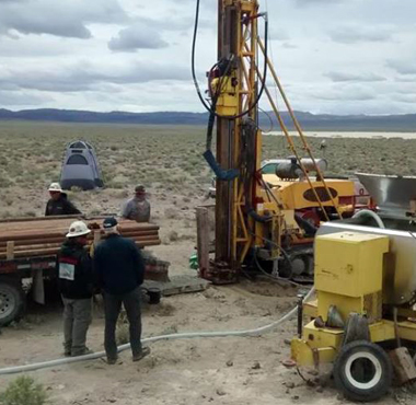
Now being mobilized, an electromagnetic survey will help target brine aquifers on Belmont Resources’ (TSXV:BEA) Kibby Basin property. The company describes Quantec Geoscience’s Spartan AMT/MT method as “a full tensor magnetotelluric technology that acquires resistivity data in the 10 kHz to 0.001 Hz frequency band. The result is a measurement that is applicable from near-surface to potential depths of three kilometres or more.” Belmont credits Quantec with over 5,000 geophysical programs in over 50 countries.

“That data looks fantastic!

Thank you for all your efforts, and thank the crew as well.  They did a great job on this project.”


Brian Bengert, President of BFG consulting.

BFG Consulting specializes in  geophysical consulting for base metal and gold exploration mineral exploration companies.

Toronto, ON – October 4, 2017 – Sierra Metals Inc. (TSX: SMT) (BVL: SMT) (NYSE American: SMTS) (“Sierra Metals” or “the Company”) is pleased to announce the initial results of the drilling program designed to test the anomalies of the Titan 24 Geophysical Survey recently completed on the Bolivar Property, Chihuahua, Mexico. The Titan 24 survey was completed to follow up on geophysical, geological and geochemical anomalies identified on the Bolivar Property by Sierra Metals Inc. The Bolivar Property is situated within the Piedras Verdes Mining District, which is located within the major north-northwest trending Sierra Madre Precious Metals Belt extending across the states of Chihuahua, Durango and Sonora in northwestern Mexico.

Alonso Lujan, Vice President, Exploration for Sierra Metals commented: “The Titan 24 survey highlighted over 40 specific areas of interest requiring further investigation and follow up. The 3D inversion modelling of the data provided an excellent tool for further exploration and highlights the overall structure below the deposit, in addition to similar structures and mineralization to the north of the deposit.”  He continued, “The company began the first phase of a drilling program to test the most promising anomalies and drilled the first four holes.  The results were very positive as indicated in Table 1 and 2 below and therefore the potential remains open for further exploration in these areas and the other multiple geophysical anomaly targets.”

Igor Gonzales, President and CEO of Sierra Metals stated “The results of the Titan 24 program and the subsequent assay results are exceptional and reflect a high correlation between copper mineralization and the priority targets identified in the geophysical survey.  We are excited about the prospects of drilling all the priority geophysical targets and the completion of follow-on drilling on these new discoveries.  This program aims to potentially quantify new high-grade zones which is a key strategic objective for our Bolivar mine to better define a path to future development and growth at the Bolivar operations”. He concluded, “We are encouraged by the exploration potential that these results are showing which could lead to further value growth for Sierra Metals in Mexico.”


Visit full press release:

http://www.sierrametals.com/investors/news-releases/press-release-details/2017/Sierra-Metals-Discovers-Several-Wide-High-grade-Copper-Structures-in-the-First-Four-Holes-Designed-to-Test-Geophysical-Targets-at-the-Bolivar-Property/default.aspx

From: Curt Freeman [mailto:avalon@avalonalaska.com]
Sent: Thursday, August 3, 2017 11:31 AM
Elaha – thanks, we will review and get back to you if we have any comments.

In the mean time, I wanted to pass on my thanks for a job well done to Jeff, Alex, Darcy and all the Quantec crew who worked on our recent Alaska Project.

Safe, efficient and drama-free, your efforts are much appreciated!

Curt

SIERRA METALS DEFINES HIGH GRADE SILVER-GOLD
MINERALIZATION AT THE LA SIDRA ZONE AND HIGH GRADE
COPPER AT THE BOLIVAR WEST ZONE LOCATED AT THE
BOLIVAR MINE, MEXICO

See Full News Release:   http://www.sierrametals.com

  • Drilling program continues to confirm high-grade silver-gold mineralization and
    substantial true widths at the “La Sidra” vein
  • Drilling is currently active on the Bolivar West zone. A recent geophysical program
    utilizing Titan 24 techniques has targeted near-surface, coincident strong chargeability
    (IP) and resistivity anomalies in the Southwestern sector of the property near Bolivar
    West.
  • Exploration programs targeted to increase tonnage and grade

Perumin 33 Mining Convention

Arequipa Peru,

From September 18 to 22, 2017

https://www.convencionminera.com/perumin33/index.php/en


Deep and Real 3D DCIP & MT, An ORION 3D Survey at Charcas Project, San Luis de Potosí, México

Authors: Jimmy Stephen, Eugenio Migliano (Grupo), Alfonso Martinez(Grupo) and Leduar Ramayo

Today we are seeing that the mining industry is focusing on deep exploration. Quantec Geoscience offers true 3D DCIP & MT (ORION 3D) acquisition through multi-directional set up. Generally conventional DCIP technologies collect data in two dimensions and invert it in 3D, which is not as accurate as ORION 3D multi-directional array data collection. The aim of this work is to show how ORION 3D technology measures three parameters for effective mapping of mineralization, alteration, structure and geology to depth (2 km) and obtaining high quality data from an environment in which data acquisition tasks and survey operations are challenging. Charcas historical case is summarized here to give an idea of some of the benefits of performing an ORION 3D survey at San Luis de Potosi mining district, Mexico.