

Ryley Killam will be presenting an interesting talk on applications of MT
Some Highlights include…
Emerging technology and processes for exploration. Deep magnetotelluric resistivity imaging is providing new insights into large scale regional exploration as well as solving local exploration issues and leading to discovery.
Robert L. Gordon MBA., P. Eng., FGC, Quantec Geoscience, Ryley Killam P.Geo., Quantec Geoscience*
Abstract
Geophysical exploration for mineral deposits has typically searched directly for ore bodies by looking for a region with anomalous properties such as density, resistivity, magnetic susceptibility or chargeability. Many ore bodies are formed by processes that occur in convergent plate boundaries such as subduction zones. Studying these processes can give insights into the formation and distribution of deposits. The mineral systems approach expands the exploration scope by looking for the entire system that formed the ore body, including regions where fluids originated, flow pathways and structures that caused mineral deposition. The value of this approach is being investigated by a number of recent initiatives in both governmental and university research. These studies use 3-D exploration methods that image to crustal and upper mantle depths.
One of the most promising technologies for these deep investigations has been magnetotellurics (MT). This method, invented in the 1950’s, uses natural electromagnetic signals to measure the electrical resistivity of the Earth. The use of MT in exploration was limited through the 1990’s. Since 2000 its use in deposit scale exploration has increased, although until recently widescale use across the mining industry has been limited. Following a number of high-profile MT exploration successes, such as the discovery of a set of low resistivity fingers beneath the world class IOCG deposit at Olympic Dam (Geology 2006), there has been an increase in MT regional and exploration surveys.
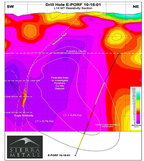
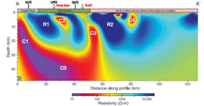
This paper will highlight how MT can be used on a range of spatial scales that extend from regional (10-100 km) to local (10-0.1 km) mineral exploration. Examples presented will include (1) regional scale government funded initiatives from Western Australia and Ontario, (2) regional scale exploration in Northern Canada, (3) local scale surveys in Ontario and British Columbia, and (4) mine site exploration, where the geophysical study contributed directly to the discovery of a new porphyry system below the mine.
Comments are closed