
Líder mundial en la adquisición de datos MT.
Quantec es líder mundial en la adquisición de datos MT. Nos hemos centrado en recopilar los mejores datos profundos posibles para nuestros clientes mediante el desarrollo de receptores MT y la mejora continua de las metodologías de adquisición de datos.
The SPARTAN MT survey is highly versatile and can be quickly deployed for both local and regional mapping. Survey designs can be tailored to different needs, including 1D for vertical data at a single site, 2D with survey lines spaced from 100m to 10 km, and 3D with grids of regular or irregular station spacing. The resulting resistivity data aids in drill planning for near-surface exploration, while also providing deep structural insights up to 2000m and mapping mineral systems up to 50 km deep.
Explorando con MT desde el año 2000
Uno de los estudios más sofisticados y precisos para proporcionar imágenes de resistividad de superficie a profundidad para una variedad de aplicaciones regionales, locales y remotas.
¿Qué es SPARTAN MT?
SPARTAN MT es una robusta tecnología audiomagnetotelúrica de tensor completo que adquiere datos de alta calidad en la banda de frecuencia de 10 kHz a 0,001 Hz. Los datos se presentan como resistividades y se correlacionan con la geología, la estructura y los posibles yacimientos geotérmicos. El sistema SPARTAN MT de Quantec ofrece un método único y eficaz para obtener resistividad profunda en diversos terrenos. Con alta portabilidad y una implementación flexible, SPARTAN MT es ecológico y no invasivo. La profundidad de investigación abarca desde la superficie hasta 10 000 m y más.
La experiencia demostrada en adquisición MT permite a Quantec proporcionar datos de alta calidad e interpretaciones eficaces que mapean con precisión las resistividades a profundidad. Los sistemas SPARTAN se implementan globalmente, tanto en modo MT como DCIP, para ofrecer a los clientes configuraciones únicas adaptadas a entornos exigentes donde se requieren imágenes profundas y datos de alta calidad.
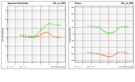
La MT (magnetotelúrica) es una técnica electromagnética pasiva que mapea la resistividad midiendo las corrientes telúricas inducidas en la tierra por fuentes naturales: rayos, erupciones solares y resonancias ionosféricas. La MT infiere las propiedades eléctricas del subsuelo terrestre a partir de mediciones de los campos eléctricos y magnéticos naturales en la superficie terrestre. SPARTAN MT es un sistema de adquisición de datos de 10 canales y 24 bits (véase el diagrama a continuación); en cada sitio de MT, se ejecutan 10 canales simultáneamente y se pueden recopilar 6 mediciones de campo magnético. Spartan MT utiliza 3 bobinas de alta frecuencia (AF) y 3 de baja frecuencia (LF) para lograr la máxima sensibilidad y la mayor calidad de datos posible. Al medir datos tensoriales completos en la banda de frecuencia de 10 kHz a 0,001 Hz, el sistema puede alcanzar una profundidad de investigación que va desde cerca de la superficie hasta 10 km o más.
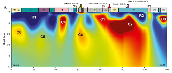
Sección de resistividad derivada de la recopilación de datos MT. Sección 2D mostrada hasta 1500 metros.
Diseño de encuesta flexible y adquisición de datos de alta calidad
SPARTAN MT puede implementarse en diversas configuraciones según sus necesidades de exploración. Dependiendo de la iniciativa de exploración y el presupuesto, SPARTAN puede implementarse en transectos para recopilar información 2D o, en algunos casos, se pueden utilizar grandes patrones de cuadrícula o incluso ubicaciones de despliegue aleatorias, adaptadas a topografías, geología, cultura, etc., para adquirir conjuntos de datos 3D. Los datos se integran fácilmente con otros tipos de datos para mejorar la interpretación. Datos de alta calidad: la medición de tensor completo proporciona sensibilidad y precisión. El sistema Quantec es muy portátil y robusto. Dependiendo de la configuración, un sitio MT puede requerir una configuración como la que se muestra a continuación.
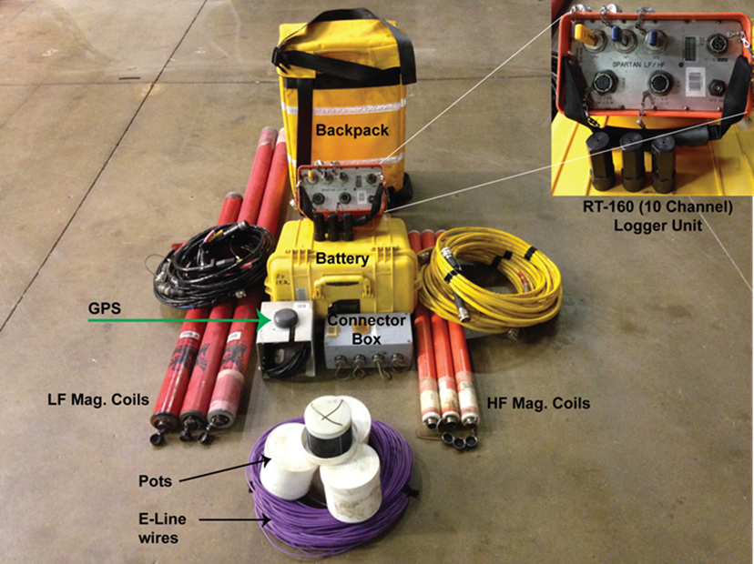
Sistema portátil para despliegue rápido
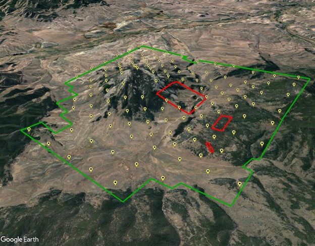
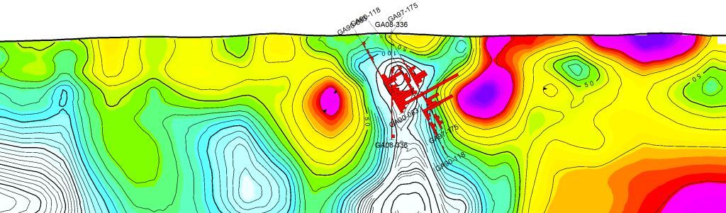
Plano de estudio de SPARTAN MT, ubicaciones de los sitios con secciones excluidas en rojo
¿Cuándo utilizar SPARTAN MT?
Exploración superficial (0-1000 m): espaciamiento estrecho entre estaciones (~200 m), grabación de AMT (banda de audio magnetotelúrica) de alta frecuencia
Evaluación y exploración de objetivos regionales: amplio espaciamiento entre estaciones (500 m – 1000 m), registro de baja frecuencia
Sitios mineros y otros entornos culturalmente ruidosos donde se requieren investigaciones locales más profundas cerca de depósitos. – implementación flexible y capacidad de registrar señales en presencia de ruido
Complemento sísmico: situaciones en las que la señal sísmica se degrada por la presencia de material volcánico, muy meteorizado, kárstico o cobertura de permafrost cerca de la superficie.