
Comparative Analysis: TEM vs. MT at Salar de Antofalla, Argentina
Investigating large identified prospective terrain may involve using multiple techniques.
Key objectives of the survey were:
- Image the subsurface location and geometry of buried conductive features
- Map deeper portions of the salar
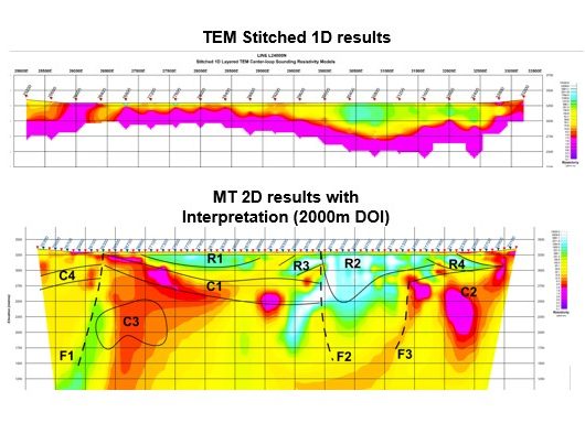
TEM (Transient electromagnetics can effectively map conductive features. However, too much conductivity will impede the ability of the technique to penetrate below shallower stronger conductors.
•Effective to ~300m depth
•Abrupt signal loss at conductive interface
•Provides high-resolution shallow data
MT (Magnetotellurics) penetrates much deeper and can highlight more subtle features.
•Penetrates to ~2,000m depth
•Images through conductive layers
•Reveals full basin architecture
Data comparison insights – Consistency in overlapping zones
Both methods show excellent correlation in the upper 300m and highlights the validity of each technique
New geological understanding as MT exposes previously hidden structures: Deep conductive zones (potential secondary brine reservoirs) as well as basement topography and possible fault systems.
Interpretation Enhancement: The client’s geological interpretation (shown here) integrates: TEM near-surface details as well as MT deep structural framework
Title: Deep resistivity study
Geology: Kibby Basin
Client: Belmont Resources
Technology: SPARTAN MT
Location: Nevada, USA
Sector: Mining – Critical minerals